

 Livres anciens
 Images
 Fonds Jean Bernabé
 Fonds René Maran
 Esclaves de Guyane
 Esclavage en Martinique
 Catalogue collectif des périodiques
 Audio-Vidéo
 Études et recherches
 Etudes Caribéennes
 Tramil
 Or
Or Esclavage et résistances
  | Au pied du Morne St.Michel- Coté Nord Auteur(s) : Direction Générale des Travaux Publics Éditeur(s) : Direction Générale des Travaux Publics Direction Générale des Travaux Publics ( Haiti ) Résumé : This collection of over 5,000 black and white photographs held by the National Archives of Haiti dates from 1918 to 1945. It contains images of public buildings before and after restoration, public works, monuments, and the visits of U.S. Presidents and other officials. Haiti Droits : All rights reserved by the National Archives of Haiti. 10179 http://ufdc.ufl.edu/AA00010382/00001 | Partager |
 | Routier Auteur(s) : Amaral, Paes do  Extrait de : Frontières entre le Brésil et la Guyane française. Annexes : tableaux et cartes (Planche 4) Résumé : Carte représentant la côte Nord Est du Brésil Siècle(s) traité(s) : 18 Droits : Domaine public Permalien : http://www.manioc.org/images/B_CG973FRAN_RES_004-10071_001_0004 B_CG973FRAN_RES_004-10071_001_0004 | Partager Voir aussi Télécharger |
| | Reconstitution du Padrón Real Auteur(s) : Chaves, Alonzo de 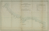 Extrait de : Frontières entre le Brésil et la Guyane française. Annexes : tableaux et cartes (Planche 2) Résumé : Carte espagnole servant pour la navigation Carte représentant le cote Nord Est de l'Amérique du Sud Siècle(s) traité(s) : 16 Droits : Domaine public Permalien : http://www.manioc.org/images/B_CG973FRAN_RES_004-10071_001_0002 B_CG973FRAN_RES_004-10071_001_0002 | Partager Voir aussi Télécharger |
| | PL. X East coast of Martinique, looking north.  Extrait de : The Lesser Antilles () Résumé : Côte Est de la Martinique vue vers le Nord Siècle(s) traité(s) : 19 Droits : Domaine public Permalien : http://www.manioc.org/images/NAN130340104i1 NAN130340104i1 | Partager |
| | PL. V The central volcanic range of St. Kitts, looking northeast. Mt. Brimstone on the left. 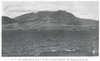 Extrait de : The Lesser Antilles () Résumé : La chaine volcanique centrale de Saint Kitts, orientée vers le Nord Est, le Mt. Brimstone sur le côté gauche Siècle(s) traité(s) : 19 Droits : Domaine public Permalien : http://www.manioc.org/images/NAN130340075i1 NAN130340075i1 | Partager Documents liés : Télécharger |
| | Partie de l'Amérique tirée du globe de Zurich  Extrait de : Mémoire contenant l'exposé des droits de la France dans la question des frontières de la Guyane française et du Brésil soumise à l'arbitrage du gouvernement de la Confédération suisse. Atlas (N°5 bis) Résumé : Reproduction de la côte de l'Amérique de sud entre l'Amazone et l'Orénoque. Le Vincent-Pinzon, première grande rivière au nord de l'Amazone, débouche par environ I° 30 ' au nord de l'Equateur Siècle(s) traité(s) : 16 Droits : Domaine public Permalien : http://www.manioc.org/images/B_CG973FRAN_RES_004-15008_001_005b B_CG973FRAN_RES_004-15008_001_005b | Partager Voir aussi Télécharger |
| | Fig. 17 The northern side of Nevis, looking east. Extrait de : The Lesser Antilles (p. 60) Résumé : Le côté Nord de Nevis dirigé vers l'Est Siècle(s) traité(s) : 19 Droits : Domaine public Permalien : http://www.manioc.org/images/NAN130340084i1 NAN130340084i1 | Partager |
| | Fig- 55 A lightly cliffed headland on the north coast of St. Croix. Extrait de : The Lesser Antilles (p. 143) Résumé : Dessin d'une baie de la côte Nord de Saint Croix Siècle(s) traité(s) : 19 Droits : Domaine public Permalien : http://www.manioc.org/images/NAN130340177i1 NAN130340177i1 | Partager |
| | Partie orientale du littoral guyanais  Extrait de : Frontières entre le Brésil et la Guyane française. Annexes : tableaux et cartes (Planche 3) Résumé : Carte représentant la côte Nord Est du Brésil Siècle(s) traité(s) : 18 Droits : Domaine public Permalien : http://www.manioc.org/images/B_CG973FRAN_RES_004-10071_001_0003 B_CG973FRAN_RES_004-10071_001_0003 | Partager Voir aussi Télécharger |
| | Fig. 57 The non-cliffed north coast of St. Croix at Christiansted. Extrait de : The Lesser Antilles (p. 144) Résumé : Dessin de la côte Nord de Sainte Croix Siècle(s) traité(s) : 19 Droits : Domaine public Permalien : http://www.manioc.org/images/NAN130340178i2 NAN130340178i2 | Partager |
| | Fig. 29 The Petit Piton, next north of the Grand Piton on the southwest coast of St. Lucia; looking east.  Extrait de : The Lesser Antilles (p. 82) Résumé : Le Petit Piton, côté nord du Grand Piton au Sud Ouest de Sainte Lucie Siècle(s) traité(s) : 19 Droits : Domaine public Permalien : http://www.manioc.org/images/NAN130340110i2 NAN130340110i2 | Partager |
| | Carta nautica del Mar Costas y Islas de las Indias Occidentales Auteur(s) : Ruesta, Sebastian de (....-1674)  Extrait de : Frontières entre le Brésil et la Guyane française. Second mémoire présenté par les Etats-Unis du Brésil au Gouvernement de la Confédération Suisse, arbitre choisi selon les stipulations du traité conclu à Rio-de-Janeiro, le 10 avril 1897 entre le Brésil et la France. Tome VI. Atlas (N°14) Résumé : Carte représentant la côte nord est de l'Amérique du Sud et les Antilles Siècle(s) traité(s) : 17 Droits : Domaine public Permalien : http://www.manioc.org/images/B_CG973FRAN_RES_00F-15010_006_0014 B_CG973FRAN_RES_00F-15010_006_0014 | Partager Voir aussi Télécharger |
| | NORVMBEGA ET VIRGINIA. 1597. Auteur(s) : Wytfliet, Cornelius (15..-1597?) Année de publication :  Éditeur(s) : Fabri, François (Douai) Extrait de : Histoire universelle des Indes orientales et occidentales, divisée en deux livres, le premier par Cornille Wytfliet, le second par Ant. M.agini et autres historiens (entre p. 120 et 121) Résumé : Côte du nord-est des Etats-Unis de Virginie à Cap Breton (Nouvelle-France) Siècle(s) traité(s) : 16 Permalien : http://www.manioc.org/images/BBX17003-0196i1 BBX17003-0196i1 | Partager |
| | Fig. 8 Center Hill, on the northwest coast of Montserrat, showing the deeply incised inner valleys between sharply serrated ridges, the moderately dissected lower slopes, and the low cliffs of the shore. The higher cliffs in the left foreground are part of Silver Hill, Fig. 6.  Extrait de : The Lesser Antilles (p. 47) Résumé : Dessin de Center Hill, sur la côte nord ouest de Montserrat montrant des plateaux profondéments incisés Siècle(s) traité(s) : 19 Droits : Domaine public Permalien : http://www.manioc.org/images/NAN130340067i1 NAN130340067i1 | Partager |
| | Fig. 58 The north coast of eastern St. Croix. Extrait de : The Lesser Antilles (p. 145) Résumé : Dessin de la côte Nord de l'Est de Sainte Croix Siècle(s) traité(s) : 19 Droits : Domaine public Permalien : http://www.manioc.org/images/NAN130340179i2 NAN130340179i2 | Partager |
| | Eriksted, showing the absence of shore cliffs. Extrait de : The Lesser Antilles (p. 145) Résumé : Dessin de la côte Nord de Sainte Croix Siècle(s) traité(s) : 19 Droits : Domaine public Permalien : http://www.manioc.org/images/NAN130340179i1 NAN130340179i1 | Partager |
 | Chronostratigraphy and sedimentology of the Boudinar and Arbaa Taourirt neogene basins (eastern Rif, Morocco) ; Chronostratigraphie et sédimentologie des bassins néogènes de Boudinar et d’Arbaa Taourirt (Rif oriental, Maroc) Auteur(s) : achalhi, mohammed Auteurs secondaires : Géosciences Montpellier ; Université des Antilles et de la Guyane (UAG) - Institut national des sciences de l'Univers (INSU - CNRS) - Université de Montpellier (UM) - Centre National de la Recherche Scientifique (CNRS) Une bourse du centre national pour la recherche scientifique et technique « CNRST » (Maroc) Université Mohammed Premier, Faculté des sciences Oujda (Maroc) Ali Azdimousa Philippe Münch PHC Volubilis N° MA/12/274, Actions Marges-MedOcc chantier “Alboran” European Project : 612572, EC:FP7:PEOPLE, FP7-PEOPLE-2013-IRSES, MEDYNA(2014) Éditeur(s) : HAL CCSD Résumé : The Neogene geodynamics evolution of the south-Alboran realm in western Mediterranean has been clarified, based on sedimentological and chronostratigraphical studies. This work focuses on three main themes of research, the first is to establish the moments for the opening and closing of the North Rifian Corridor by studying two Neogene basins of the southern edge of the Alboran sea. The second, aims to understand the behavior of these two basins face a major event in the history of the Mediterranean: The Messinian Salinity Crisis. Finally, the third theme aims to understand the modalities Post-MSC reflooding in the southern part of the Alboran realm.The late Miocene evolution of the North Rifian Corridor is clarified on the basis of chronostratigraphic studies of the Neogene Boudinar and Arbaa Taourirt basins (northeastern Morocco). The marine sediments deposited in the Boudinar basin between the early Tortonian and the late early Messinian (10 Ma to 6.1 Ma) and in the late Tortonian-earliest Messinian interval in the Arbaa Taourirt basin. Palaeoenvironmental data record a major drowning in association with extensive tectonics in the Boudinar basin during the early Messinian at ~7.2 Ma. At the same time, prograding conglomerates and sandstones developed over the late Tortonian marls in the Arbaa Taourirt basin. During the late-early Messinian, a shallowing trend occurred in the Boudinar basin. Thus, the North Rifian Corridor opened at ~7.2 Ma ensuring Atlantic-Mediterranean connections, then was progressively restricted during the late-early Messinian and totally closed at ~6.1 Ma. New sedimentological and paleontological studies of the late Messinian-early Pliocene deposits in the Boudinar basin provide new information on the Messinian Salinity Crisis (« MSC ») and the Zanclean reflooding in the Alboran sea. The Messinian erosional surface « MES » is of late Messinian age and was emplaced in subaerial settings. It is polygenic, its original geometry is locally preserved and was re-shaped by the Pliocene transgressive surface. Above the « MES », the Boudinar basin infill is characterized by a wide variety of facies from continental settings to lower offshore conditions. Two major sets are recognized: a latest Messinian-Zanclean set that constitutes a transgressive-regressive megasequence interrupted at the top by a tectonic unconformity, and an Plio-Quaternary regressive set. During the late Messinian Zanclean interval, four successive depositional models were documented. They record major changes in palaeoflow and paleogeography related to base-level fluctuations. No Gilbert-type delta has ben identified at Boudinar. the beginning of base-level rise is marked by normal regressions and by the formation of several lacs and fan-delta complexes on the margins of the basin in the late Messinian and befor the marine reefloding in the early Zanclean. The marine reflooding of the basin appears later, with a transgressive surface of ravinment and a thick package of transgressive deposits. These transgressive deposits onlap over all previous deposits. The major part of the basin infill did not issue from an inner landward position (south of the basin) but from the northwestern side of the basin, i.e. near the Mediterranean. Sediments were subsequently reworked by storms and transported by longshore-drift towards the south. a maximum flooding surface is found several tens of metres above the « MES ». This fiding is consistent with a progressive and not a catastrophic early Zanclean flooding of the westernMediterranean after the Mediterranean base-level fall. Sur la base d’études sédimentologiques et chronostratigraphiques dans les bassins de Boudinar et d’Arbaa Taourirt (Rif oriental, Maroc), l’évolution géodynamique néogène du domaine sud-Alboran en Méditerranée occidentale a été clarifiée. Ce travail est axé sur trois grandes thématiques de recherche. La première vise à l’établissement d’un cadre chronostratigraphique pour l’ouverture et la fermeture du Couloir Nord Rifain, par l’étude de deux bassins nèogènes de la bordure sud de la mer d’Alboran. La deuxième, vise à comprendre le comportement de ces deux bassins face à un événement majeur de l’histoire de la Mediterranée : la Crise de salinité messinienne. Finalement, la troisième vise à comprendre les modalités de remise en eau de la Méditerranée après la Crise : le reenoiement pliocène. L'évolution du Couloir Nord Rifain au Miocène supérieur est clarifiée sur la base des études chronostratigraphiques des bassins néogènes de Boudinar et d'Arbaa Taourirt (Maroc Nord oriental). Les sédiments marins miocènes se sont déposés entre le Tortonien inférieur et le Messinien inférieur (10 à 6.1 Ma) dans le bassin de Boudinar et entre le Tortonien supérieur et le Messinien inférieur dans le bassin d'Arbaa Taourirt. Les données paléoenvironnementales enregistrent un ennoyage important du bassin de Boudinar en relation avec une tectonique extensive pendant le Messinien inférieur (~7.2 Ma). En même temps, des conglomérats et de grès progradants se sont développés au-dessus des marnes tortoniennes dans le bassin d’Arbaa Taourirt. Le bassin de Boudinar a subi un désapprofondissement au Messinien inférieur. Ces résultats indiquent que le Couloir Nord Rifain s’est ouvert à ~7.2 Ma assurant les communications entre l’Atlantique et la Méditerranée, puis a subi une restriction progressive pendant le Messinien inférieur avant d’être totalement fermé à ~6.1 Ma.De nouvelles études sédimentologiques et paléontologiques des dépôts Messinien supérieur-Pliocène inférieur dans le bassin de Boudinar fournissent des informations sur la Crise de salinité messinienne (« MSC ») et le réennoiement zancléen dans la Mer d'Alboran. L’un des marqueurs majeurs de la Crise est identifié : la surface d’érosion messinienne « MES ». Elle est d'âge Messinien supérieur et a été mise en place dans des conditions subaériennes. Sa géométrie originale n’est préservée que localement et a été remodelée par la surface transgressive du Pliocène inférieur. Au dessus de la « MES » le remplissage sédimentaire du bassin de Boudinar est caractérisé par une grande variété de faciès allant des conditions de dépôts continentales jusqu’à des conditions d’offshore inférieur. Deux ensembles majeurs sont reconnus : un ensemble messinien terminal-zancléen qui constitue une mégaséquence transgressive-regressive, interrompue au sommet par une discordance tectonique, et un ensemble plio-quaternaire regressif. Durant l’intervalle Messinien terminal-Zancléen, quatre modèles de dépôts successifs ont été documentés enregistrant des changements majeurs de paléocourants et de paléogéographies, liés aux fluctuations de niveau de base. Nous n’avons pas identifié de Gilbert delta à Boudinar. La remontée du niveau de base est marquée par une régression normale et par le développement des lacs et de complexes de fan-deltas sur les marges du bassin pendant le Messinien supérieur, avant l’inondation marine au Zancléen basal. Le réennoiement marin du bassin apparait plus tard avec une surface de transgression ravinante et par d’épais dépôts transgressifs, en onlap sur tous les dépôts précédents. La majeure partie du remplissage sédimentaire du bassin n’est pas reçue des reliefs de la bordure sud du bassin, mais du côté Nord-Ouset au bord de la Méditerranée. Les sédiments sont alors remaniés par les tempêtes et transportés vers le sud par la dérive littorale. Une surface d’inondation maximale a été identifiée à plusieurs dizaines de mètres au-dessus de la « MES ». Ceci suggère un ennoiement progressif et non catastrophique, après la chute du niveau de base méditerranéen. https://tel.archives-ouvertes.fr/tel-01473572 Droits : http://hal.archives-ouvertes.fr/licences/copyright/ tel-01473572 https://tel.archives-ouvertes.fr/tel-01473572 https://tel.archives-ouvertes.fr/tel-01473572/document https://tel.archives-ouvertes.fr/tel-01473572/file/Th%C3%A8se-achalhi.pdf | Partager |
| | Grandes Antilles - Saint-Domingue  Extrait de : Manuel de la navigation dans la mer des Antilles et dans le golfe de Mexique : vues de cotes (Pl. 10) Résumé : Vue N °4. Presqu'ile de Samana à 13 milles. Vue N° 5. Presqu'ile de Samana à 7 milles. Vue N° 6. Côte Nord de St-Domingue Droits : Domaine public Permalien : http://www.manioc.org/images/SCH131460034i1 SCH131460034i1 | Partager |
 | Approche sectorielle subtidale : Identification et caractérisation des habitats benthiques du secteur Glénan (Réseau de surveillance benthique - Région Bretagne) Auteur(s) : Ehrhold, Axel Blanchet, Aline Hamon, Dominique Résumé : Ifremer launched and coordinated the development of a strategy for the REBENT network (REseau BENThique) in 2000 to monitor the aftermath of the "Erika" oil spill in December 1999. Its aim is to provide consistent baseline knowledge about coastal benthic habitats and constitute a monitoring tool to detect changes at various scales over time and space. Sector-based seabed habitat mapping in shallow water (< 50 m deep), is currently being conducted throughout Brittany's coastal waters through a combination of geoacoustic marine systems and ground-truthing using biological grab sampling and seabed observations.
Sedimentological and biological results on Glenan area emphasize a great diversity of subtidal habitats and marine species recognized. Sidescan imagery accentuates the complexity of the communities structure in a marine environment distinguished by strong and regulary roughness of the sea. Maerl biocenose is present at the nord-east of the archipelago. Progressively it gives way to mud sediment colonized by Amphiura filiformis and Haploops in the deeper channel. To the west and the south, substratum types are more coarse, occasionally mobiles, composed of essentially sand community with Nephtys and gravelly sand community with Branchiostoma lanceolatum.
Le Rebent (Réseau benthique), initié en 2000 à la suite de la catastrophe de l'Erika, a pour objectif de suivre les habitats benthiques côtiers et de détecter les changements à différentes échelles de temps et d'espace. L'approche sectorielle dans les petits fonds (< 50 m) des côtes bretonnes combine, des moyens de prospection acoustique, afin de délimiter les principaux types de substrats, avec des prélèvements et des observations biologiques pour caractériser les peuplements macrobenthiques. Les résultats des analyses sédimentologiques et faunistiques montrent autour de l'archipel des Glénan, une grande diversité d'habitats et d'espèces reconnues. L'imagerie acoustique fait ressortir la complexité de leur structuration dans un environnement marin soumis à de fortes et régulières périodes d'agitation. La biocénose de maërl occupe le nord-est de l'archipel. Elle laisse place progressivement aux sédiments envasés à Amphiura filiformis et aux vases à Haploops dans le fond du chenal. A l'ouest et au sud, les subtrats sont plus grossiers, essentiellement sableux à Nephtys et sablo-graveleux à Branchiostoma lanceolatum, épisodiquement mobiles. Droits : info:eu-repo/semantics/openAccess http://archimer.ifremer.fr/doc/2006/rapport-2301.pdf http://archimer.ifremer.fr/doc/2006/sup-2301.pdf http://archimer.ifremer.fr/doc/00000/2301/ | Partager Voir aussi Haploops maerl bedforms bedload transport communities benthic macrofauna sidescan sonar habitats mapping Glenan Rebent Télécharger |
 | Research framework for the developpement of creole pig's niche lmarket in Martinique : a holistic approach" ; Cadre de recherches pour le développement du marché de niches du porc créole martinique : une apprache holistique Auteur(s) : Gourdine, Jean-Luc Année de publication : Loading the player... Éditeur(s) : INRA : Institut National de la Recherche Agronomique Université des Antilles. Service commun de la documentation Extrait de : 52e congrès annuel de la Société caribéenne des plantes alimentaires / 52nd annual meeting of the Caribbean food crops society (CFCS), du 10 au 16 juillet 2016. INRA, CFCS Description : The Creole pig has always been part of the rural and suburban landscape of Martinique. Currently, this breed is not integrated into a research and conservation program. The Natural Park of Martinique Region (PNRM) has the objective to maintain and valorize the genetic heritage of Martinique?s Creole pig and develop a niche business. Based on PNRM knowledge, some Creole pigs live freely in the mountains in the North, in the South coast and in a few disparate traditional breeders located in the countryside. It is essential to carry out an inventory of the local pig population to propose a scheme for conservation and economic development. In order to favour the appropriation of the Creole pig niche, the PNRM, as a decision maker, acts in a systemic and holistic way by considering the whole Martinican territory and the pig sub-sector: producers involved in the COOPMAR pig farmers? cooperative, researchers of INRA (FWI), the food chain and at least (in a second phase) the consumers and the Martinican society. First of all, the pig farmers are involved (private family farms and specialised pig producers). Researchers and technicians from PNRM and INRA- URZ (Animal production research unit) and INRA-PTEA (Tropical platform in animal experimentation) are performing experimental studies both in controlled conditions and in farms, in order to: i) determine phenotypic and genetic characteristics of Martinique?s Creole pigs in comparison with other pig breeds from the Caribbean area; ii) help at designing genetic management to maintain the population and avoiding inbreeding; iii) help at defining feeding management by a) establishing, at the whole territorial food chain, an inventory of co or by-products available for pig feeding; b) implementing experimental studies in technology for conservation; c) implementing feeding and growing experiments and finally iv) help at defining eco-friendly production systems a) aiming at generate an adequate revenue and b) focusing on ecosystem services such as meat quality, socio-cultural services and circular economy. Le porc créole a toujours fait partie du paysage rural et suburbain de la Martinique. Actuellement, cette race n'est pas intégrée dans un programme de recherches et de conservation. Le parc naturel de la région de la Martinique (PNRM) a l'objectif pour maintenir et valoriser l'héritage génétique du porc créole de la Martinique et pour développer des créneaux. Basé sur la connaissance de PNRM, quelques porcs créoles vivent librement dans les montagnes dans le nord, dans la côte sud et chez quelques éleveurs traditionnels disparates situés dans la campagne. Il est essentiel d'effectuer un inventaire de la population locale de porc pour proposer un plan pour la conservation et le développement économique. Afin de favoriser l'appropriation du créneau créole de porc, le PNRM, comme décideur, agit d'une manière systémique et holistique en considérant tout le territoire de la Martinique et sous-secteur de porc : producteurs impliqués dans la coopérative d'agriculteurs de porc de COOPMAR, les chercheurs d'AICN (FWI), la chaîne alimentaire et au moins (dans une deuxième phase) les consommateurs et la société Martiniquaise. Tout d'abord, les agriculteurs de porc sont impliqués (les fermes privées de famille et les producteurs de porc spécialisés). Les chercheurs et les techniciens de PNRM et AICN URZ (unité de recherches de production animale) et INRA-PTEA (plate-forme tropicale chez l'expérimentation animale) réalisent des études expérimentales dans des conditions commandées et dans les fermes : i) déterminent des caractéristiques phénotypiques et génétiques des porcs créoles de la Martinique en comparaison d'autres races de porc à partir du secteur des Caraïbes ; ii) aide à concevoir la gestion génétique pour maintenir la population et à éviter l'endogamie ; iii) aide à définir la gestion de alimentation a) en établissant, à la chaîne alimentaire territoriale de totalité, à un inventaire de Co ou aux sous-produits disponibles pour l'alimentation de porc ; b) mise en oeuvre des études expérimentales en technologie pour la conservation ; c) mettant en application des expériences de alimentation et croissantes et finalement iv) aide à définir viser qui respecte l'environnement des systèmes de production a) produisent de à revenu approprié et b) se concentrant sur des services d'écosystème tels que la qualité de viande, des services socioculturels et l'économie circulaire. Siècle(s) traité(s) : 21 Droits : CC-BY-NC-ND - Attribution - Pas d'utilisation commerciale - Pas de modification Permalien : http://www.manioc.org/fichiers/V16263 V16263 | Partager |
