Dominican Republic city graphic 110,000 : Puerto Plata ; Puerto Plata ; República Dominicana plano de ciudad 110,000 ; Series E931 ; Serie E931 Auteur(s) : United States -- National Imagery and Mapping Agency Instituto Cartográfico Militar (Dominican Republic) Éditeur(s) : National Imagery and Mapping Agency National Imagery and Mapping Agency ( Bethesda, Maryland ) Résumé : (Language) In English and Spanish. Relief shown by contours and spot heights ; contour interval 25 meters. "Revised in 1994 from best available sources". "Printed by NIMA 5-99". "NIMA ref. no. E931XPUERTOPLAT". Includes legend, glossary, guide to numbered features, index to streets, hydrographic data, inset map of Cofresí, city location map and boundary diagram. (Statement of Responsibility) prepared by the Instituto Cartográfico Militar (ICM), Santo Domingo, Dominican Republic, in collaboration with the National Imagery and Mapping Agency (NIMA). Dominican Republic -- Puerto Plata -- San Felipe San Felipe de Puerto Plata (Dominican Republic) 77739233 003712596 | Partager |
Grundriss des Hafens von Acapulco ; Plan du port d'Acapulco sur la cote du Mexique dans la Mer du Sud Auteur(s) : Bellin, Jacques Nicolas, 1703-1772 Prévost, 1697-1763 Éditeur(s) : [s.n.] ( [Leipzig] ) Résumé : From German edition of Histoire Generale des Voyages..., by Prevost d'Exiles. Attributed to Bellin. Relief shown pictorially. Includes graphic scale in English miles. "16°45' Norderbreite und 108°22' Westlicher Loenge von London." "No 16." (Funding) Funded in part by the University of Florida, the Florida Heritage Project of the State University Libraries of Florida, the Institute for Museum and Library Services, and the U.S. Department of Education's TICFIA granting program. Acapulco (Mexico) Acapulco (Mexico) Acapulco (Mexico) Mexico, Cities Acapulco Acapulco (Mexico) Acapulco (Mexico) Acapulco (Mexico) Droits : This item is presumed to be in the public domain. The University of Florida George A. Smathers Libraries respect the intellectual property rights of others and do not claim any copyright interest in this item. Users of this work have responsibility for determining copyright status prior to reusing, publishing or reproducing this item for purposes other than what is allowed by fair use or other copyright exemptions. Any reuse of this item in excess of fair use or other copyright exemptions may require permission of the copyright holder. The Smathers Libraries would like to learn more about this item and invite individuals or organizations to contact Digital Services (UFDC@uflib.ufl.edu) with any additional information they can provide. 002356783 ALW1211 122378930 http://ufdc.ufl.edu/UF00066670/00001 | Partager |
Plan de La Grande Saline l'une des Isles Turques Auteur(s) : Bellin, Jacques Nicolas, 1703-1772 Bellin, Jacques Nicolas, 1703-1772 Éditeur(s) : Didot ( Paris ) Résumé : From: Description des débouquements qui sont au nord de l'isle de Saint Domingue. "Pl.XXIII." Philips No. 3949; Map # 23. Relief shown pictorially, dephs by pathoms. (Funding) Funded in part by the University of Florida, the Florida Heritage Project of the State University Libraries of Florida, the Institute for Museum and Library Services, and the U.S. Department of Education's TICFIA granting program. Turks and Caicos Islands Turks and Caicos Islands Turks and Caicos Islands Turks and Caicos Islands Turks and Caicos Islands Turks and Caicos Islands Droits : This item is presumed to be in the public domain. The University of Florida George A. Smathers Libraries respect the intellectual property rights of others and do not claim any copyright interest in this item. Users of this work have responsibility for determining copyright status prior to reusing, publishing or reproducing this item for purposes other than what is allowed by fair use or other copyright exemptions. Any reuse of this item in excess of fair use or other copyright exemptions may require permission of the copyright holder. The Smathers Libraries would like to learn more about this item and invite individuals or organizations to contact Digital Services (UFDC@uflib.ufl.edu) with any additional information they can provide. 002869167 APA0340 83698065 http://ufdc.ufl.edu/UF00003797/00001 | Partager |
Haiti city map 1:12,500 : Fort Liberté ; Fort Liberté, Haiti ; Series E935 Auteur(s) : United States -- Defense Mapping Agency. -- Hydrographic/Topographic Center Éditeur(s) : United States Defense Mapping Agency Hydrographic / Topographic Center ( Bethesda, Maryland ) Résumé : (Language) Parallel text in English and French. Relief shown by contours and spot heights. Title from upper margin. "Prepared and published by the Defense Mapping Agency Hydrographic/Topographic Center." "Printed by DMAHTC 10-94." "Limited revisions in purple as of 1987." Includes inset guide to numbered features, glossary, and reference guide. DMA STOCK NO. E935XFORTLIBE. Haiti -- Fort Liberté Fort Liberté (Haiti) Droits : This item is a work of the U.S. federal government and not protected by copyright pursuant to 17 U.S.C. §105. 49731683 002787237 http://ufdc.ufl.edu/UF00098769/00001 | Partager |
Profils en long et en travers du canal proposé pour la jonction des deux océans à travers l'Isthmé de Panama ; Plan du Port de Chagrès ; Plan de la partie inferieure du cours de la rivière de Chagrès Éditeur(s) : s.n. ( France ) Résumé : Maps: Plan du Port de Chagrès à l'echelle de 1 á 20,000 -- Plan de la partie inferieure du cours de la rivière de Chagrès entre son embouchure dans l'Atlantique et le confluent du Rio Trinidad à l'echelle de 1 à 50,000 (relief shown by hachures and depth by soundings). Panama Panama Canal (Panama) Chagres River (Panama) Chagres (Panama) Droits : This item is presumed to be in the public domain. The University of Florida George A. Smathers Libraries respect the intellectual property rights of others and do not claim any copyright interest in this item. Users of this work have responsibility for determining copyright status prior to reusing, publishing or reproducing this item for purposes other than what is allowed by fair use or other copyright exemptions. Any reuse of this item in excess of fair use or other copyright exemptions may require permission of the copyright holder. The Smathers Libraries would like to learn more about this item and invite individuals or organizations to contact Digital Services (UFDC@uflib.ufl.edu) with any additional information they can provide. 43275248 http://ufdc.ufl.edu/UF00100941/00001 | Partager |
Karte von der Erdenge Panama und den Provinzen Veragua, Terra Firma und Darien Auteur(s) : Bellin, Jacques Nicolas, 1703-1772 Prévost, 1697-1763 Éditeur(s) : [s.n.] ( [Leipzig] ) Résumé : Relief shown pictorially. Prime meridian: Paris. "No. 6." From German edition of Histoire Generale des Voyages..., by Prevost d'Exiles, Antoine F. Includes scale in French miles. (Funding) Funded in part by the University of Florida, the Florida Heritage Project of the State University Libraries of Florida, the Institute for Museum and Library Services, and the U.S. Department of Education's TICFIA granting program. (Statement of Responsibility) zur allgemeinen Historie der Reisen, von dem Hrn Bellin ; Ing. de la Marine. Panama Panama Panama Panama Panama Panama Droits : This item is presumed to be in the public domain. The University of Florida George A. Smathers Libraries respect the intellectual property rights of others and do not claim any copyright interest in this item. Users of this work have responsibility for determining copyright status prior to reusing, publishing or reproducing this item for purposes other than what is allowed by fair use or other copyright exemptions. Any reuse of this item in excess of fair use or other copyright exemptions may require permission of the copyright holder. The Smathers Libraries would like to learn more about this item and invite individuals or organizations to contact Digital Services (UFDC@uflib.ufl.edu) with any additional information they can provide. 002356827 ALW1255 38306490 http://ufdc.ufl.edu/UF00066659/00001 | Partager |
St. Vincent ; Philip's Atlas of the world comprising a series of maps & charts constructed from the most authentic sources accompanied by a concise view of general & physical geography Auteur(s) : George Philip & Son Rhind, William, 1797-1864 Éditeur(s) : George Philip & Son ( London, London ) Résumé : Relief indicated by hachures. "West from London" below "61⁰15ʹ" on bottom of map. "c. 1853" penciled on bottom of map. Saint Vincent and the Grenadines Saint Vincent Droits : This item is presumed to be in the public domain. The University of Florida George A. Smathers Libraries respect the intellectual property rights of others and do not claim any copyright interest in this item. Users of this work have responsibility for determining copyright status prior to reusing, publishing or reproducing this item for purposes other than what is allowed by fair use or other copyright exemptions. Any reuse of this item in excess of fair use or other copyright exemptions may require permission of the copyright holder. The Smathers Libraries would like to learn more about this item and invite individuals or organizations to contact Digital Services (UFDC@uflib.ufl.edu) with any additional information they can provide. 665169589 http://ufdc.ufl.edu/UF00102962/00001 | Partager |
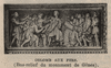
Colomb aux fers. ( Bas-relief du monument de Gênes ) Année de publication : Extrait de : Manuel d'histoire d'Haïti (Page 22) Résumé : Gravure représentant un bas-relief illustrant la scène de l'arrestation de Christophe Colomb à Hispaniola par un représentant de la Cour d'Espagne,à la suite d'accusations concernant sa façon d'administrer l'île. Siècle(s) traité(s) : 15 Droits : Domaine public Permalien : http://www.manioc.org/images/PAP110770032i1 PAP110770032i1 | Partager |
The British Islands in the West Indies Auteur(s) : J. & C. Walker Society for the Diffusion of Useful Knowledge (Great Britain) Baldwin & Cradock Éditeur(s) : Baldwin & Craddock ( London ) Résumé : "Published under the Superintendence of the Society for the Diffusion of Useful Knowledge." Relief shown by hachures. (Funding) Funded in part by the University of Florida, the Florida Heritage Project of the State University Libraries of Florida, the Institute for Museum and Library Services, and the U.S. Department of Education's TICFIA granting program. (Statement of Responsibility) engraved by J. & C. Walker. British Virgin Islands Trinidad and Tobago Saint Vincent and the Grenadines Grenada Jamaica Saint Lucia Bahamas Anguilla Dominica Cayman Islands Barbados West Indies Droits : This item is presumed to be in the public domain. The University of Florida George A. Smathers Libraries respect the intellectual property rights of others and do not claim any copyright interest in this item. Users of this work have responsibility for determining copyright status prior to reusing, publishing or reproducing this item for purposes other than what is allowed by fair use or other copyright exemptions. Any reuse of this item in excess of fair use or other copyright exemptions may require permission of the copyright holder. The Smathers Libraries would like to learn more about this item and invite individuals or organizations to contact Digital Services (UFDC@uflib.ufl.edu) with any additional information they can provide. 003374099 13213503 http://ufdc.ufl.edu/UF00029171/00001 | Partager |
A Map of Jamaica Barbados ; Map of Jamaica ; Barbados Auteur(s) : Speed, John, 1552?-1629 Éditeur(s) : Sold by Thomas Bassett in Fleetstreet and Richard Chiswell in St. Pauls Churchyard ( [London] ) Résumé : Relief shown pictorially. Has elegant heraldic title cartouches and elaborate mileage scale cartouches. Jamaica is shown divided into precincts. On verso: Full page descriptions of jamaica and Barbados. From Speed's Prospect of the Most Famous Parts of the World. (Funding) Funded in part by the University of Florida, the Florida Heritage Project of the State University Libraries of Florida, the Institute for Museum and Library Services, and the U.S. Department of Education's TICFIA granting program. Jamaica Barbados Jamaica Barbados Jamaica Barbados Droits : This item is presumed to be in the public domain. The University of Florida George A. Smathers Libraries respect the intellectual property rights of others and do not claim any copyright interest in this item. Users of this work have responsibility for determining copyright status prior to reusing, publishing or reproducing this item for purposes other than what is allowed by fair use or other copyright exemptions. Any reuse of this item in excess of fair use or other copyright exemptions may require permission of the copyright holder. The Smathers Libraries would like to learn more about this item and invite individuals or organizations to contact Digital Services (UFDC@uflib.ufl.edu) with any additional information they can provide. 003374048 12875143 http://ufdc.ufl.edu/UF00029181/00001 | Partager |
Haiti city map 1:12,500 : Port-De-Paix ; Port-De-Paix ; Series E935 Auteur(s) : United States -- Defense Mapping Agency. -- Hydrographic/Topographic Center United States -- National Imagery and Mapping Agency Haiti -- Service de géodésie Éditeur(s) : United States Defense Mapping Agency Hydrographic / Topographic Center ( Bethesda, Maryland ) Résumé : (Language) Parallel text in English and French. Relief shown by contours and spot heights. Contour interval 10 meters. Title from upper margin. Includes inset guide to numbered features, and glossary. "NSN 7643014017128." "NIMA REF. NO. E935XPORTDEPAIX." (Statement of Responsibility) prepared by Engineers of the Service de Géodésie et des Forces Armées d'Haiti under the supervision of the Département des Travaux Publics and with the collaboration of the United States Army Inter American Geodetic Survey. Revised in 1987 from the best available sources by the Defense Mapping Agency Hydrographic/Topographic Center. Haiti -- Port-De-Paix Port-de-Paix (Haiti) Port-de-Paix (Haiti) Droits : This item is a work of the U.S. federal government and not protected by copyright pursuant to 17 U.S.C. §105. 49847876 002771569 http://ufdc.ufl.edu/UF00098771/00001 | Partager |
Haiti, 1:100,000 ; Series E632 Auteur(s) : Haiti -- Service de géodésie et de cartographie Inter American Geodetic Survey Haiti -- Armée Éditeur(s) : Service de géodésie et de cartographie ( Port-au-Prince? ) Résumé : Some maps printed by Army Map Service, Corps of Engineers. Relief shown by contours and spot heights. English and French. Standard maps series designation: Series E632. Some maps lack series statement. Includes index to adjacent sheets, glossary, explanatory chart. Some maps have index to boundaries. (Statement of Responsibility) compilée par le Service de Géodésie et de Cartographie et les Forces Armées d'Haiti sous le supervision du Département des Travaux Publics et avec la collaboration de la U.S. Army Inter American Geodetic Survey. Haiti Haiti Droits : This item is a work of the U.S. federal government and not protected by copyright pursuant to 17 U.S.C. §105. 12307066 http://ufdc.ufl.edu/UF00078625/00001 | Partager |
Nicaragua city graphic 1:12,500 : Bluefields ; Series E956 ; Bluefields Auteur(s) : United States -- Defense Mapping Agency. -- Hydrographic/Topographic Center United States -- National Imagey and Mapping Agency Éditeur(s) : United States Defense Mapping Agency, Hydrographic / Topographic Center ( Bethesda, Maryland ) Résumé : (Language) Parallel text in English and Spanish. Relief shown by contours and spot heights. Contour interval 20 meters, supplementary contours 10 meters. "Compiled in 1991 from best available sources." "NIMA REF No. E956XBLUEFIELDS." Includes inset, location map, glossary, indexes, and boundary diagr. (Statement of Responsibility) prepared and published by the Defense Mapping Agency, Hydrographic/Topographic Center. Nicaragua -- Bluefields Bluefields (Nicaragua) Bluefields (Nicaragua) Droits : This item is a work of the U.S. federal government and not protected by copyright pursuant to 17 U.S.C. §105. 49850064 002802723 http://ufdc.ufl.edu/UF00098807/00001 | Partager |
Carte de l'isle de la Guadeloupe Auteur(s) : Bellin, Jacques Nicolas, 1703-1772 Prévost, 1697-1763 Éditeur(s) : Chez Didot ( Paris, Paris ) Résumé : Original coordinates on map based on Prime Meridian: Paris. Shows parishes, towns, forts, churches, coast shoals and relief. Relief shown pictorially. "Tom. XV." below bottom neat line at left "No. 13." below bottom neat line at right. (Statement of Responsibility) Par M.B., ingr. de la mare. 1758. Gaudeloupe Guadeloupe Droits : This item is presumed to be in the public domain. The University of Florida George A. Smathers Libraries respect the intellectual property rights of others and do not claim any copyright interest in this item. Users of this work have responsibility for determining copyright status prior to reusing, publishing or reproducing this item for purposes other than what is allowed by fair use or other copyright exemptions. Any reuse of this item in excess of fair use or other copyright exemptions may require permission of the copyright holder. The Smathers Libraries would like to learn more about this item and invite individuals or organizations to contact Digital Services (UFDC@uflib.ufl.edu) with any additional information they can provide. 664683385 http://ufdc.ufl.edu/UF00102967/00001 | Partager |
Dominican Republic city plans 1:12,500 : Santo Domingo and Vicinity ; Santo Domingo and Vicinity ; Dominican Republic city plans ; Santo Domingo and Vicinity, Dominican Republic ; Series E931 Auteur(s) : United States -- Army Map Service Éditeur(s) : United States Army Map Service ( Washington, D. C. ) Résumé : "Planimetric detail revised by AMS in 1965 by photo-planimetric methods from aerial photography dated April 1965." Relief shown by contours and spot heights. English and Spanish. Alternate title: Santo Domingo and vicinity, Dominican Republic. " ... 1,000 meter universal transverse Mercator grid, Zone 19 ..." Standard map series designation: Series E931. Includes index and glossary. (Statement of Responsibility) prepared by the Army Map Service (AM), Corps of Engineers, U.S. Army. Dominican Republic -- Santo Domingo Santo Domingo (Dominican Republic) Droits : This item is a work of the U.S. federal government and not protected by copyright pursuant to 17 U.S.C. §105. 12343948 85690393 001635947 http://ufdc.ufl.edu/UF00098759/00001 | Partager |
Plan de la ville du Cap Francais et de ses environs ; Box title: Isle Saint Domingue maps Auteur(s) : Phelipeaux, R. Résumé : Library copy included with three other maps folded to 27 x 19 cm. in box with title: Isle Saint Domingue. Library copy dissected and mounted on cloth. Hand-coloring distinguishes masonry, wood and projected structures. "Le Cap à l'eglise méridienne 74d 38m 25s, latitude 19d 46m 24s" ; revised from Paris to Greenwich meridian in this description. "Dédié à Monseigneur Le Maréchal de Castries, chevalier des ordres du Roi, ministre et secrétaire d'etat de la marine, par son très humble et très respectueux serviteur René Phelipeau, géographe, rue de la Harpe près celle du foin." Includes inset drawing of bridge spanning the Haut du Cap river. Oriented with North to the right. Relief shown by hachures and shading. Depths shown by soundings. Droits : This item is presumed to be in the public domain. The University of Florida George A. Smathers Libraries respect the intellectual property rights of others and do not claim any copyright interest in this item. Users of this work have responsibility for determining copyright status prior to reusing, publishing or reproducing this item for purposes other than what is allowed by fair use or other copyright exemptions. Any reuse of this item in excess of fair use or other copyright exemptions may require permission of the copyright holder. The Smathers Libraries would like to learn more about this item and invite individuals or organizations to contact Digital Services (UFDC@uflib.ufl.edu) with any additional information they can provide. 77008219 http://ufdc.ufl.edu/UF00028442/00001 | Partager Voir aussi |
Haiti 1:25,000 Auteur(s) : Haiti -- Service de géodésie Haiti -- Armée Inter American Geodetic Survey Éditeur(s) : Le Service ( Port-au-Prince ) Résumé : Printed by U.S. Army Engineer Service, Corozal, C.Z. Relief shown by contours and spot heights. Includes index to adjacent sheets. (Statement of Responsibility) preparée par les ingenieurs du Service de Géodésie et de l'Armée d'Haiti sous la supervision du Departement des Travaux Publics et avec la collaboration de l'U.S. Army Inter American Geodetic Survey. Haiti Haiti Droits : This item is a work of the U.S. federal government and not protected by copyright pursuant to 17 U.S.C. §105. 11863920 http://ufdc.ufl.edu/UF00078624/00001 | Partager |
Map of the Bahama Islands Auteur(s) : Cram, George Franklin, 1841-1928 Cram, George Franklin, 1841-1928 Éditeur(s) : Cram ( Chicago, Chicago ) Résumé : Relief shown by hachures. Includes ancillary map of western Cuba and Florida Keys on verso. Bahamas Cuba United States of America -- Florida Bahamas Droits : This item is presumed to be in the public domain. The University of Florida George A. Smathers Libraries respect the intellectual property rights of others and do not claim any copyright interest in this item. Users of this work have responsibility for determining copyright status prior to reusing, publishing or reproducing this item for purposes other than what is allowed by fair use or other copyright exemptions. Any reuse of this item in excess of fair use or other copyright exemptions may require permission of the copyright holder. The Smathers Libraries would like to learn more about this item and invite individuals or organizations to contact Digital Services (UFDC@uflib.ufl.edu) with any additional information they can provide. 665171205 http://ufdc.ufl.edu/UF00102960/00001 | Partager |
Hispaniola insula Auteur(s) : Wytfliet, Corneille Éditeur(s) : [s.n.] ( [Louvain ) Résumé : Relief shown pictorially. Shows drainage, settlements, etc. From: Descriptionis Ptolemaicae ... [map 9]. (Funding) Funded in part by the University of Florida, the Florida Heritage Project of the State University Libraries of Florida, the Institute for Museum and Library Services, and the U.S. Department of Education's TICFIA granting program. Haiti Dominican Republic Hispaniola Hispaniola Droits : This item is presumed to be in the public domain. The University of Florida George A. Smathers Libraries respect the intellectual property rights of others and do not claim any copyright interest in this item. Users of this work have responsibility for determining copyright status prior to reusing, publishing or reproducing this item for purposes other than what is allowed by fair use or other copyright exemptions. Any reuse of this item in excess of fair use or other copyright exemptions may require permission of the copyright holder. The Smathers Libraries would like to learn more about this item and invite individuals or organizations to contact Digital Services (UFDC@uflib.ufl.edu) with any additional information they can provide. 003374466 61356964 http://ufdc.ufl.edu/UF00029167/00001 | Partager |
Trinidad 1:62,500 / ; Series E742 Auteur(s) : United States -- Army Map Service Éditeur(s) : Army Map Service, U.S. Army, Army Map Service, U.S. Army Army Map Service, U.S. Army, Army Map Service, U.S. Army ( Washington, D.C ) Résumé : (Internal Comments) prepared under the direction of the Chief of Engineers, U.S. Army, by the Army Map Service. (Statement of Responsibility) prepared under the direction of the Chief of Engineers, U.S. Army, by the Army Map Service. Relief shown by contours and spot heights. Complete in 8 sheets. Military grid. "Contour interval 25, 50 feet changing to 100 feet at 100 foot contour." Six classes of roads or trails are shown. Provisional edition, 1940, by U.S. Army, Corps of Engineers, has title "Trinidad and Tobago .. Tactical map." Marginal map: Index to sheets. Trinidad and Tobago -- Trinidad Trinidad 06455957 | Partager |