Rechercher
Toutes les collections
Livres anciens
Images
Fonds Jean Bernabé
Fonds René Maran
Esclaves de Guyane
Audio-Vidéo
Études et recherches
Études caribéennes
Tramil
Or
Esclavage
Gallica
DLOC
Ifremer
Thèses.fr
HAL-UA
BNPM
UWI
Recherche avancée
Patrimoine
Livres anciens
Images
Fonds Jean Bernabé
Fonds René Maran
Esclaves de Guyane
Esclavage en Martinique
Catalogue collectif des périodiques
Recherche
Audio-Vidéo
Études et recherches
Etudes Caribéennes
Tramil
Thématiques
Or
Esclavage et résistances
120 documents satisfont la requête.
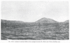
Fig. 20 The southwestern coast of Dominica.
Extrait de
:
The Lesser Antilles (p. 69)
Résumé
: Dessin de la côte sud ouest de l'île de la Dominique
Siècle(s) traité(s)
: 19
Droits
: Domaine public
Permalien
:
http://www.manioc.org/images/NAN130340093i1
NAN130340093i1
Partager
|
Plus
Voir aussi
Documents liés
:
http://www.manioc.org/patrimon/NAN13034
Télécharger
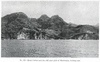
Seen from Blackbeard Castle on a hill back of the town; looking south
Extrait de
:
The Lesser Antilles (p. 113)
Résumé
: Dessin de bord de mer et des montagnes
Siècle(s) traité(s)
: 19
Droits
: Domaine public
Permalien
:
http://www.manioc.org/images/NAN130340145i1
NAN130340145i1
Partager
|
Plus
Voir aussi
Documents liés
:
http://www.manioc.org/patrimon/NAN13034
Télécharger
Fig. 54 Ham bluff, the precipitous northwest coast of St. Croix.
Extrait de
:
The Lesser Antilles (p. 142)
Résumé
: Dessin du précipité, Nord Ouest de Saint Croix
Siècle(s) traité(s)
: 19
Droits
: Domaine public
Permalien
:
http://www.manioc.org/images/NAN130340176i1
NAN130340176i1
Partager
|
Plus
Voir aussi
Documents liés
:
http://www.manioc.org/patrimon/NAN13034
Télécharger
PL. VIII Isolated residual hills in the passage between St. Kitts and Nevis, looking east.
Extrait de
:
The Lesser Antilles (p. 54)
Résumé
: Collines isolées au niveau du passage entre Saint Kitts et Nevis
Siècle(s) traité(s)
: 19
Droits
: Domaine public
Permalien
:
http://www.manioc.org/images/NAN130340078i1
NAN130340078i1
Partager
|
Plus
Voir aussi
Documents liés
:
http://www.manioc.org/patrimon/NAN13034
Télécharger
Fig. 61 The subdued mountains of volcanic rocks in the southwestern quarter of Antigua. No shore cliffs are seen here.
Extrait de
:
The Lesser Antilles (p. 149)
Résumé
: Dessin de subdivisions des montagnes volcaniques d'une partie d'Antigua
Siècle(s) traité(s)
: 19
Droits
: Domaine public
Permalien
:
http://www.manioc.org/images/NAN130340183i1
NAN130340183i1
Partager
|
Plus
Voir aussi
Documents liés
:
http://www.manioc.org/patrimon/NAN13034
Télécharger
Fig. 17 The northern side of Nevis, looking east.
Extrait de
:
The Lesser Antilles (p. 60)
Résumé
: Le côté Nord de Nevis dirigé vers l'Est
Siècle(s) traité(s)
: 19
Droits
: Domaine public
Permalien
:
http://www.manioc.org/images/NAN130340084i1
NAN130340084i1
Partager
|
Plus
Voir aussi
Documents liés
:
http://www.manioc.org/patrimon/NAN13034
Télécharger
Fig. 48 Cockroach Island, northwest of St. Thomas, looking north.
Extrait de
:
The Lesser Antilles (p. 120)
Résumé
: Dessin de la falaise de l'île Cockroach, Nord Ouest de Saint Thomas
Siècle(s) traité(s)
: 19
Droits
: Domaine public
Permalien
:
http://www.manioc.org/images/NAN130340152i3
NAN130340152i3
Partager
|
Plus
Voir aussi
Documents liés
:
http://www.manioc.org/patrimon/NAN13034
Télécharger
Fig. 35 The inner part of the delta plain of Cul de Sac, St. Lucia, looking northwest. See also Fig. 30.
Extrait de
:
The Lesser Antilles (p. 101)
Résumé
: La partie intérieure de la barrière du Cul de Sac, versant Nord Ouest de Sainte Lucie
Siècle(s) traité(s)
: 19
Droits
: Domaine public
Permalien
:
http://www.manioc.org/images/NAN130340129i1
NAN130340129i1
Partager
|
Plus
Voir aussi
Documents liés
:
http://www.manioc.org/patrimon/NAN13034
Télécharger
Fig- 55 A lightly cliffed headland on the north coast of St. Croix.
Extrait de
:
The Lesser Antilles (p. 143)
Résumé
: Dessin d'une baie de la côte Nord de Saint Croix
Siècle(s) traité(s)
: 19
Droits
: Domaine public
Permalien
:
http://www.manioc.org/images/NAN130340177i1
NAN130340177i1
Partager
|
Plus
Voir aussi
Documents liés
:
http://www.manioc.org/patrimon/NAN13034
Télécharger
Fig. 34 An elevated cliff-base platform, near Wellington, New Zealand.
Extrait de
:
The Lesser Antilles (p. 87)
Résumé
: Dessin de la plateforme à la base de la falaise près de Wellington, Nouvelle Zélande
Siècle(s) traité(s)
: 19
Droits
: Domaine public
Permalien
:
http://www.manioc.org/images/NAN130340115i2
NAN130340115i2
Partager
|
Plus
Voir aussi
Documents liés
:
http://www.manioc.org/patrimon/NAN13034
Télécharger
Fig. 21 An embayed and cliffed part of the east coast of Dominica (from U. S. Hydrogr. Office Chart No. 1318).
Extrait de
:
The Lesser Antilles (p. 71)
Résumé
: Une partie de la côte Est de l'île de la Dominique
Siècle(s) traité(s)
: 19
Droits
: Domaine public
Permalien
:
http://www.manioc.org/images/NAN130340095i1
NAN130340095i1
Partager
|
Plus
Voir aussi
Documents liés
:
http://www.manioc.org/patrimon/NAN13034
Télécharger
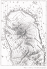
Fig. I Ideal section of a Lesser Antillean bank
Extrait de
:
The Lesser Antilles (p. 15)
Siècle(s) traité(s)
: 19
Droits
: Domaine public
Permalien
:
http://www.manioc.org/images/NAN130340031i1
NAN130340031i1
Partager
|
Plus
Voir aussi
Documents liés
:
http://www.manioc.org/patrimon/NAN13034
Télécharger
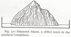
Fig. 52 Diamond Island, a cliffed stack in the southern Grenadines.
Extrait de
:
The Lesser Antilles (p. 131)
Résumé
: Dessin de l'île du Diamant au Sud des Grenadines
Siècle(s) traité(s)
: 19
Droits
: Domaine public
Permalien
:
http://www.manioc.org/images/NAN130340163i1
NAN130340163i1
Partager
|
Plus
Voir aussi
Documents liés
:
http://www.manioc.org/patrimon/NAN13034
Télécharger
PL. IX Mont Carbet and the cliff spur ends of Martinique, looking east.
Extrait de
:
The Lesser Antilles ()
Résumé
: Mont Carbet et vue des falaises côté est de la Martinique
Siècle(s) traité(s)
: 19
Droits
: Domaine public
Permalien
:
http://www.manioc.org/images/NAN130340103i1
NAN130340103i1
Partager
|
Plus
Voir aussi
Documents liés
:
http://www.manioc.org/patrimon/NAN13034
Télécharger
Fig. 24 Cliff and stack of southernmost Martinique.
Extrait de
:
The Lesser Antilles (p. 75)
Résumé
: Dessin d'une falaise et d'un rocher en Martinique
Siècle(s) traité(s)
: 19
Droits
: Domaine public
Permalien
:
http://www.manioc.org/images/NAN130340099i3
NAN130340099i3
Partager
|
Plus
Voir aussi
Documents liés
:
http://www.manioc.org/patrimon/NAN13034
Télécharger
Fig. 32 The east coast of St. Lucia (from U. S. Hydrogr. Office Chart No. 1261).
Extrait de
:
The Lesser Antilles (p. 86)
Résumé
: Carte topographique de la côte Est de Sainte Lucie
Siècle(s) traité(s)
: 19
Droits
: Domaine public
Permalien
:
http://www.manioc.org/images/NAN130340114i1
NAN130340114i1
Partager
|
Plus
Voir aussi
Documents liés
:
http://www.manioc.org/patrimon/NAN13034
Télécharger
Subdued volcanic mounts, formerly independent islets, are now attached
Extrait de
:
The Lesser Antilles (p. 81)
Résumé
: Dessin des volcans en formation vue de la mer
Siècle(s) traité(s)
: 19
Droits
: Domaine public
Permalien
:
http://www.manioc.org/images/NAN130340109i1
NAN130340109i1
Partager
|
Plus
Voir aussi
Documents liés
:
http://www.manioc.org/patrimon/NAN13034
Télécharger
Fig. 19 Morne au Diable (from U. S. Hydrogr. Office Chart N0. 1318).
Extrait de
:
The Lesser Antilles (p. 66)
Résumé
: Carte topographique du Morne au Diable
Siècle(s) traité(s)
: 19
Droits
: Domaine public
Permalien
:
http://www.manioc.org/images/NAN130340090i1
NAN130340090i1
Partager
|
Plus
Voir aussi
Documents liés
:
http://www.manioc.org/patrimon/NAN13034
Télécharger
Figs. 12 and 13 St. Kitts (from U.S.
Extrait de
:
The Lesser Antilles (p. 52)
Résumé
: Carte topographique de Saint Kitts
Siècle(s) traité(s)
: 19
Droits
: Domaine public
Permalien
:
http://www.manioc.org/images/NAN130340072i1
NAN130340072i1
Partager
|
Plus
Voir aussi
Documents liés
:
http://www.manioc.org/patrimon/NAN13034
Télécharger
Fig. 31 The low cliffs of the mid-west coast, St. Lucia.
Extrait de
:
The Lesser Antilles (p. 85)
Résumé
: Dessin de falaises de la côte centre ouest de Sainte Lucie
Siècle(s) traité(s)
: 19
Droits
: Domaine public
Permalien
:
http://www.manioc.org/images/NAN130340113i1
NAN130340113i1
Partager
|
Plus
Voir aussi
Documents liés
:
http://www.manioc.org/patrimon/NAN13034
Télécharger


 Livres anciens
 Images
 Fonds Jean Bernabé
 Fonds René Maran
 Esclaves de Guyane
 Esclavage en Martinique
 Catalogue collectif des périodiques
 Audio-Vidéo
 Études et recherches
 Etudes Caribéennes
 Tramil
 Or
Or Esclavage et résistances