

 Livres anciens
 Images
 Fonds Jean Bernabé
 Fonds René Maran
 Esclaves de Guyane
 Esclavage en Martinique
 Catalogue collectif des périodiques
 Audio-Vidéo
 Études et recherches
 Etudes Caribéennes
 Tramil
 Or
Or Esclavage et résistances
  | Les citadines "blanches" et libres de couleur à la Martinique : dimension économique et sociale (1802-1806) Auteur(s) : Bechet, Laëticia Auteurs secondaires : Elbaz, Gilbert Rogers, Dominique Année de publication : Loading the player... Éditeur(s) : CRILLASH : Centre de Recherches Interdisciplinaires en Lettres, Langues, Arts et Sciences Humaines Extrait de : Conférence des masters, les 29 et 30 mars 2012. Université des Antilles et de la Guyane Description : Laëticia Bechet nous présente un sujet intéressant sur les femmes "blanches" et libres de couleur en Martinique au début du XIXe siècle. Elle étudie particulièrement les citadines de Saint-Pierre et Fort-Royal entre 1802 et 1806, à travers les sources notariales (testaments, actes de mariage, de vente de biens mobiliers et immobiliers...), la presse (La Gazette de la Martinique) et les travaux des chercheurs. Siècle(s) traité(s) : 19 Droits : CC-BY-NC-ND - Attribution - Pas d'utilisation commerciale - Pas de modification Permalien : http://www.manioc.org/fichiers/V12240 V12240 | Partager Voir aussi Libre de couleur Esclavage Esclaves Famille Affranchissement Histoire Famille Femmes Economie Martinique|Fort-Royal Martinique|Saint-Pierre ; Télécharger  |
 | Fort George overlooking the city of Saint George's, Grenada ; The Bryant Slides Collection ; The Bryant Slides Collection, Grenada Auteur(s) : Unknown ( Photographer ) Résumé : The slides were taken on collecting trips sponsored by the William L. Bryant Foundation, where books, music and art indigenous to the regions were gathered. The are organized by geographical location. In the distance overlooking the harbor is Fort George, Grenada’s oldest fort which was built by the French in 1705. Fort George continues (2013) to function as the headquarters for the Royal Grenada Police Force, which it has housed since 1854 when the Colonial Government took over control of the fort. Flying above the fort is the Grenada flag (1967-1974). In 1967 when Grenada became a British Associated State, it adopted a blue-yellow-green flag with a nutmeg in the center. The nutmeg represented Grenada’s position as the “Spice Isle” and is also featured on the Coat of Arms. This flag was used until 1974 when Grenada gained independence. Below the fort is a red roofed house with a balcony and red and white striped window awnings. To the left of the fort is a two story house which is partially on stilts. To the right of the fort is a view of Saint George’s, the capital of Grenada. Slide labeled Gren. 2 Grenada -- Caribbean region -- Saint George's, Saint George Droits : All rights to images are held by the respective holding institution. This image is posted publicly for non-profit educational uses, excluding printed publication. For permission to reproduce images and/or for copyright information contact Special Collections & University Archives, University of Central Florida Libraries, Orlando, FL 32816 phone (407) 823-2576, email: speccoll@mail.ucf.edu CFM1972_01a Sheet 43:2 http://ufdc.ufl.edu/AA00029598/00001 | Partager |
| | View of the harbor and city of Saint George’s, Saint George, Grenada ; The Bryant Slides Collection ; The Bryant Slides Collection, Grenada Auteur(s) : Unknown ( Photographer ) Résumé : The slides were taken on collecting trips sponsored by the William L. Bryant Foundation, where books, music and art indigenous to the regions were gathered. The are organized by geographical location. On the left side of the image are yachts and various boats anchored in the lagoon off the coast of Saint George’s, Saint George, Grenada. As of 2013, the area above the hill belonged to Port Louis Marina. The buildings in the center of this image were built as barracks to house members of the Southern Defense Force, which was formed in 1944 during World War II. After the war, the barracks became the home of Grenada Boys’ Secondary School (GBSS). GBSS is Grenada’s oldest school, which officially began in 1885 at the Church Street location. Steamship (S.S.) Regina is shown anchored near the Grenada Port Authority pier in Saint George’s harbor. S.S. Regina, originally built in 1939, was acquired in 1964 by Chandris Cruises and renamed Regina. Her funnel features the Greek Chi symbol which was placed on Chandris ships to honor the founder’s Greek heritage. In the distance, atop the hill on the right, can be seen the dark stone walls of Fort George, Grenada’s oldest fort which was built by the French in 1705. Fort George continues (2013) to function as the headquarters for the Royal Grenada Police Force, which it has housed since 1854 when the Colonial Government took over control of the fort. Slide labeled Gren. 10 Grenada -- Caribbean region -- Saint George's, Saint George Droits : All rights to images are held by the respective holding institution. This image is posted publicly for non-profit educational uses, excluding printed publication. For permission to reproduce images and/or for copyright information contact Special Collections & University Archives, University of Central Florida Libraries, Orlando, FL 32816 phone (407) 823-2576, email: speccoll@mail.ucf.edu CFM1972_01a Sheet 43:10 http://ufdc.ufl.edu/AA00029607/00001 | Partager |
 | Fort-de-France, Martinique (Formely Fort Royal) 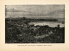 Extrait de : Two Years in the French West Indies (p. 112) Résumé : Gravure de la ville de Fort-de-France appelée autrefois Fort-Royal Siècle(s) traité(s) : 19 Droits : Domaine public Provenance : Université des Antilles et de la Guyane. Service commun de la documentation Permalien : http://www.manioc.org/images/HASH016b5cbda2c73225dc753bfc HASH016b5cbda2c73225dc753bfc | Partager Documents liés :
Télécharger |
| | Fort Fincastle and the Water Tower, New Providence, Bahamas ; The Bryant Slides Collection ; The Bryant Slides Collection, Bahamas Nassau Hope Town Auteur(s) : Unknown ( Photographer ) Résumé : The slides were taken on collecting trips sponsored by the William L. Bryant Foundation, where books, music and art indigenous to the regions were gathered. The are organized by geographical location. Fort Fincastle, completed in 1793, with its brick walls was built by the Royal Governor of the islands, Lord Dunmore (also known as Viscount Fincastle). This uniquely shaped fort has a triangular projection and rounded side which sits atop Bennet Hill. It is located near the top of the Queen's Staircase. Later, Fort Fincastle served as a lighthouse until 1816 and then was used as a signal tower. The Water Tower and cannons can be seen in the image. Bahamas -- North America --Nassau, New Providence Island Droits : All rights to images are held by the respective holding institution. This image is posted publicly for non-profit educational uses, excluding printed publication. For permission to reproduce images and/or for copyright information contact Special Collections & University Archives, University of Central Florida Libraries, Orlando, FL 32816 phone (407) 823-2576, email: speccoll@mail.ucf.edu CFM1972_01a Sheet 14:11 http://ufdc.ufl.edu/AA00029359/00001 | Partager |
| | Boats and ocean liners anchored in Saint George’s harbor, Grenada ; The Bryant Slides Collection ; The Bryant Slides Collection, Grenada Auteur(s) : Unknown ( Photographer ) Résumé : The slides were taken on collecting trips sponsored by the William L. Bryant Foundation, where books, music and art indigenous to the regions were gathered. The are organized by geographical location. Boats and ocean liners anchored in Saint George’s harbor, Grenada. A yacht with what appears to be the name Sans Souci is flying a United States of America and the Grenadan flag (1967-1974). In 1967 when Grenada became a British Associated State, it adopted a blue-yellow-green flag with a nutmeg in the center. The nutmeg represented Grenada’s position as the “Spice Isle” and is also featured on the Coat of Arms. This flag was used until 1974 when Grenada gained independence. Merchant Vessel (MV) Geestcape, partially pictured, entered service in 1966. In 1935, the Van Geest brothers in Spalding, United Kingdom started a horticultural business. The brothers later expanded their business to include a cargo service to carry horticultural produce, primarily bananas, from the Windward and Leeward Islands to Europe. MV Geestcape is also flying the flag of the British Merchant Navy, a red flag with the Union Jack in the upper left corner. Motor Ship (MS) Renaissance, behind MV Geestcape, was built in 1966. Until 1977, Renaissance operated primarily on the Marseille-Haifa route under Compagnie Navigation de Paquet (Croiseres Paquet), Marseille, France. The cruise liner had many subsequent owners throughout her history, until her disposal in 2010. She is pictured here flying the French flag. In the distance overlooking the harbor is Fort George, Grenada’s oldest fort which was built by the French in 1705. Fort George continues (2013) to function as the headquarters for the Royal Grenada Police Force, which it has housed since 1854 when the Colonial Government took over control of the fort. Slide labeled Grenada Harbor. Grenada -- Caribbean region -- Saint George's, Saint George Droits : All rights to images are held by the respective holding institution. This image is posted publicly for non-profit educational uses, excluding printed publication. For permission to reproduce images and/or for copyright information contact Special Collections & University Archives, University of Central Florida Libraries, Orlando, FL 32816 phone (407) 823-2576, email: speccoll@mail.ucf.edu CFM1972_01a Sheet 44:9 http://ufdc.ufl.edu/AA00029627/00001 | Partager |
| | """Le Fort royal dans l'Isle de la Martinique, vu du mouillage.""" Éditeur(s) : Paris : éditions Duchartre et Van Buggenhoudt Extrait de : Les frères de La Coste, Flibustiers et Corsaires (p. 230) Résumé : Vue sur la baie de Fort Royal Permalien : http://www.manioc.org/images/FCL18014-0254i1 FCL18014-0254i1 | Partager Documents liés : Télécharger |
| | Aerial view of Saint George’s, Saint George, Grenada ; The Bryant Slides Collection ; The Bryant Slides Collection, Grenada Auteur(s) : Unknown ( Photographer ) Résumé : The slides were taken on collecting trips sponsored by the William L. Bryant Foundation, where books, music and art indigenous to the regions were gathered. The are organized by geographical location. View of Saint George’s, the capital of Grenada, which is located in the parish of Saint George. Steamship (S.S.) Regina is shown docked in Saint George’s harbor. S.S. Regina, originally built in 1939, was acquired in 1964 by Chandris Cruises and renamed Regina. Her funnel features the Greek Chi symbol which was placed on Chandris ships to honor the founder’s Greek heritage. In the distance can be seen the dark stone walls of Fort George, Grenada’s oldest fort which was built by the French in 1705. Fort George continues (2013) to function as the headquarters for the Royal Grenada Police Force, which it has housed since 1854 when the Colonial Government took over control of the fort. Slide labeled Gren. 9 Grenada -- Caribbean region -- Saint George's, Saint George Droits : All rights to images are held by the respective holding institution. This image is posted publicly for non-profit educational uses, excluding printed publication. For permission to reproduce images and/or for copyright information contact Special Collections & University Archives, University of Central Florida Libraries, Orlando, FL 32816 phone (407) 823-2576, email: speccoll@mail.ucf.edu CFM1972_01a Sheet 43:9 http://ufdc.ufl.edu/AA00029606/00001 | Partager |
| | Fort George overlooking the harbor in Grenada ; The Bryant Slides Collection ; The Bryant Slides Collection, Grenada Auteur(s) : Unknown ( Photographer ) Résumé : The slides were taken on collecting trips sponsored by the William L. Bryant Foundation, where books, music and art indigenous to the regions were gathered. The are organized by geographical location. In the distance overlooking the harbor is Fort George, Grenada’s oldest fort which was built by the French in 1705. Fort George continues (2013) to function as the headquarters for the Royal Grenada Police Force, which it has housed since 1854 when the Colonial Government took over control of the fort. Below the fort is a red roofed house with a balcony and red and white striped window awnings. A small boat can be seen approaching the harbor. Slide labeled Gren. 1 Grenada -- Caribbean region -- Saint George's, Saint George Droits : All rights to images are held by the respective holding institution. This image is posted publicly for non-profit educational uses, excluding printed publication. For permission to reproduce images and/or for copyright information contact Special Collections & University Archives, University of Central Florida Libraries, Orlando, FL 32816 phone (407) 823-2576, email: speccoll@mail.ucf.edu CFM1972_01a Sheet 43:1 http://ufdc.ufl.edu/AA00029597/00001 | Partager |
| | Plan de la ville et du fort Royal de la Martinique 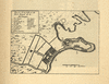 Extrait de : Saint-Pierre-Martinique 1635-1902 : Annales des Antilles françaises - Journal et album de la Martinique, naissance, vie et mort de la cité créole - livre d'or de la charité (p. 75) Résumé : Carte de la ville de Fort-de-France anciennement appelée Fort-Royal et de son fort. L'intérêt stratégique de la baie, vaste et bien protégée, n'échappe pas à Du Parquet (futur gouverneur de l'île) Siècle(s) traité(s) : 17 Droits : Domaine public Provenance : Université des Antilles et de la Guyane. Service commun de la documentation Permalien : http://www.manioc.org/images/HASH01d5cd51d0b0a1b788f73585 HASH01d5cd51d0b0a1b788f73585 | Partager Documents liés :
Télécharger |
 | Atlas des côtes de la Martinique levées pendant les années 1824 et 1825 / par M. Monnier ; secondé par M. Le Bourguignon-Duperré,... Auteur(s) : Monnier, Paul (1794-1843). Cartographe Le Bourguignon-Duperré, Cyprien Gabriel (17..-18..? ; ingénieur-hydrographe). Cartographe Éditeur(s) : Dépôt général de la marine (Paris) Résumé : Comprend : Plan des triangles de la Martinique observés dans les années 1824 et 1825 pour la reconnaissance des côtes de cette île / Par M. Monnier ; Secondé par M. Le Bourguignon Duperré ; Carte particulière des côtes de la Martinique (Partie orientale de l'Ile comprise entre la Pointe du Marigot et la Cul-de-Sac du Vauclin). Levée en 1824 et 1825 / Par M. Monnier ; Secondé par M. Le Bourguignon Duperré ; Carte particulière des côtes de la Martinique (Partie méridionale de l'Ile, comprenant la Baie du Fort-Royal, le Cul-de-Sac Marin et la côte orientale depuis la Pointe des Salines jusqu'au Cul-de-Sac du Simon. Levée en 1824 et 1825 / Par M. Monnier ; Secondé par M. Le Bourguignon Duperré ; Carte particulière des côtes de la Martinique (Partie séptentrionale de l'Ile entre la Baie du Fort-Royal et le Rocher du Pain de Sucre). Levé en 1824 et 1825 / Par M. Monnier ; Secondé par M. Le Bourguignon Duperré ; Plan de la Baie du Fort-Royal (Ile de la Martinique). Levé en 1824 / Par M. Monnier ; Secondé par M. Le Bourguignon Duperré ; Plan de la rade et de la ville de St. Pierre (Ile de la Martinique). Levé en 1825 / Par M. Monnier ; Secondé par M. Le Bourguignon Duperré ; Plan du Havre de la Trinité (Ile de la Martinique). Levé en 1824 / Par M. Monnier ; Secondé par M. Le Bourguignon Duperré ; Plan des Havres du Robert et du François (Ile de la Martinique). Levé en 1824 / Par M. Monnier ; Secondé par M. Le Bourguignon Duperré ; Plan du Cul-de-Sac Marin (Ile de la Martinique). Levé en 1824 / Par M. Monnier ; Secondé par M. Le Bourguignon Duperré Appartient à l’ensemble documentaire : FranceAm Bibliothèque nationale de France, département Cartes et plans, CPL GE DD-649 Martinique (France) Droits : domaine public http://gallica.bnf.fr/ark:/12148/btv1b6700416m | Partager |
| | Plan du Cul de Sac Royal de la Martinique Auteur(s) : Bellin, J Éditeur(s) : J. Bellin ( Paris ) Résumé : (Funding) Funded in part by the University of Florida, the Florida Heritage Project of the State University Libraries of Florida, the Institute for Museum and Library Services, and the U.S. Department of Education's TICFIA granting program. Droits : This item is presumed to be in the public domain. The University of Florida George A. Smathers Libraries respect the intellectual property rights of others and do not claim any copyright interest in this item. Users of this work have responsibility for determining copyright status prior to reusing, publishing or reproducing this item for purposes other than what is allowed by fair use or other copyright exemptions. Any reuse of this item in excess of fair use or other copyright exemptions may require permission of the copyright holder. The Smathers Libraries would like to learn more about this item and invite individuals or organizations to contact Digital Services (UFDC@uflib.ufl.edu) with any additional information they can provide. 003898933 http://ufdc.ufl.edu/UF00082300/00001 | Partager |
| | Cul de Sac Port du Carénage et Fort Royal de la Martinique en l'estat qu'il était lors de la guerre avec l'Angleterre en 1666 et 1667 Année de publication : 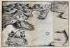 Extrait de : Trois siècles d'histoire antillaise : Martinique et Guadeloupe de 1635 à nos jours (En regard de la page 129) Résumé : Carte Siècle(s) traité(s) : 17 Droits : Domaine public Permalien : http://www.manioc.org/images/PAP110490135i1 PAP110490135i1 | Partager |
| | Fort-Royal, Jamaica 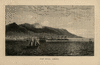 Extrait de : The English in the West Indies or the bow of Ulysses (p. 194) Résumé : Gravure représentant Fort-Royal, Jamaïque depuis la mer au 19e siècle Siècle(s) traité(s) : 19 Droits : Domaine public Provenance : Université des Antilles et de la Guyane. Service commun de la documentation Permalien : http://www.manioc.org/images/HASH8fec319025316609e74a5a HASH8fec319025316609e74a5a | Partager Voir aussi
Télécharger |
| | Vue Générale de Fort-Royal (avec les 2 pitons du Carbet au fond) 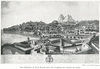 Extrait de : La Martinique au premier siècle de la colonisation ,1635-1742 ; Texte imprimé () Résumé : Vue générale de Fort Royal avec en arrière plan les 2 pitons du Carbet Siècle(s) traité(s) : 19 Droits : Domaine public Permalien : http://www.manioc.org/images/NAN130400011i1 NAN130400011i1 | Partager |
| | Attaque du Fort Royal de la Martinique par les Hollandais. (Tirée de La France des cinq parties du Monde, par Homberg). Année de publication : 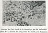 Extrait de : Histoire de la Martinique : à l'usage des cours supérieur et complémentaire des écoles primaires (p. 45) Résumé : Attaque du Fort Royal de la Martinique par les hollandais. ( Tiré de La France des cinq parties du monde, par Homberg ) Siècle(s) traité(s) : 19 Droits : Domaine public Permalien : http://www.manioc.org/images/NAN130600061i1 NAN130600061i1 | Partager Documents liés : Télécharger |
| | Port et Fort Royal de la Grenade Auteur(s) : Bellin, Jacques Nicolas, 1703-1772 Bellin, Jacques Nicolas, 1703-1772 Éditeur(s) : Bellin, Jacques Nicolas ( Paris ) Résumé : Relief shown pictorially. Depths shown in fathoms. From: Le Petit Atlas Maritime Recueil De cartes Et Plans Des Quatre Parties Du Monde."Tome I, no. 102." Philips No. 3508 Map shows location of "Fort Royal" and "La Ville". (Funding) Funded in part by the University of Florida, the Florida Heritage Project of the State University Libraries of Florida, the Institute for Museum and Library Services, and the U.S. Department of Education's TICFIA granting program. Grenada Saint George's Saint George's (Grenada) St. George's (Grenada) St. George's (Grenada) St. George's (Grenada) St. George's (Grenada) St. George's (Grenada) Droits : This item is presumed to be in the public domain. The University of Florida George A. Smathers Libraries respect the intellectual property rights of others and do not claim any copyright interest in this item. Users of this work have responsibility for determining copyright status prior to reusing, publishing or reproducing this item for purposes other than what is allowed by fair use or other copyright exemptions. Any reuse of this item in excess of fair use or other copyright exemptions may require permission of the copyright holder. The Smathers Libraries would like to learn more about this item and invite individuals or organizations to contact Digital Services (UFDC@uflib.ufl.edu) with any additional information they can provide. 002568056 AMT4355 05415827 http://ufdc.ufl.edu/UF00071895/00001 | Partager Voir aussi Harbors -- Maps -- Early works to 1800 ( lcsh ) Maps -- Early works to 1800 ( lcsh ) Early maps -- No scale -- 1764 ( local ) Early works to 1800 -- No scale -- 1764 ( local ) No scale -- 1764 ( local ) Early maps -- No scale -- 1764 ( local ) Early works to 1800 -- No scale -- 1764 ( local ) |
| | Plan of Fort Royal in the island of Granada with the Harbour & Environs. 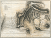 Extrait de : Candid and impartial considerations on the nature of the sugar trade ; the comparative importance of the British and French Islands in the West-Indies : with the value and consequence of St. Lucia and Granada, truly stated. Illustrated with copper-plates (Entre p. 178 et 179) Résumé : A. Fort Royal. B. Battery upon Goat Point. C. The Town. D. The Church. E. Hospital Hill & Entrenchment. F. Redoubts. G. Morne Latoniere. H. Morne Moliere. I. Morne St Edoy. K. Entrenchments. Permalien : http://www.manioc.org/images/SCH132550192i1 SCH132550192i1 | Partager |