

 Livres anciens
 Images
 Fonds Jean Bernabé
 Fonds René Maran
 Esclaves de Guyane
 Esclavage en Martinique
 Catalogue collectif des périodiques
 Audio-Vidéo
 Études et recherches
 Etudes Caribéennes
 Tramil
 Or
Or Esclavage et résistances
  | Carte de L'Isle de Nieves Auteur(s) : Bellin, Jacques Nicolas, 1703-1772 Bellin, Jacques Nicolas, 1703-1772 Éditeur(s) : [s.n.] ( Paris ) Résumé : (Citation/Reference) Philips, From: Le Petit Atlas Maritime Recueil De cartes Et Plans Des Quatre Parties Du Monde."Tome I" "No.84" Relief shown pictorially. Depths shown by fathoms. Map shows location of villages on the island of Nieves. (Funding) Funded in part by the University of Florida, the Florida Heritage Project of the State University Libraries of Florida, the Institute for Museum and Library Services, and the U.S. Department of Education's TICFIA granting program. Saint Kitts and Nevis Droits : This item is presumed to be in the public domain. The University of Florida George A. Smathers Libraries respect the intellectual property rights of others and do not claim any copyright interest in this item. Users of this work have responsibility for determining copyright status prior to reusing, publishing or reproducing this item for purposes other than what is allowed by fair use or other copyright exemptions. Any reuse of this item in excess of fair use or other copyright exemptions may require permission of the copyright holder. The Smathers Libraries would like to learn more about this item and invite individuals or organizations to contact Digital Services (UFDC@uflib.ufl.edu) with any additional information they can provide. 002357163 ALW1600 82968946 http://ufdc.ufl.edu/UF00003800/00001 | Partager |
| | Carte dell'isola della Guadelupa :/ Auteur(s) : Bellin, Jacques Nicolas, 1703-1772 Bellin, Jacques Nicolas, 1703-1772 Formaleoni, V. A ( Vincenzio Antonio ), 1752-1797 Éditeur(s) : V. Formaleoni ( Venice, Venice ) Résumé : (Citation/Reference) Phillips, Original coordinates on map based on Prime Meridian: Paris. Shows parishes, towns, forts, churches, coast shoals and relief. Relief shown pictorially. (Statement of Responsibility) di M.B. Ingre. della marina, 1781. Guadeloupe Guadeloupe Droits : This item is presumed to be in the public domain. The University of Florida George A. Smathers Libraries respect the intellectual property rights of others and do not claim any copyright interest in this item. Users of this work have responsibility for determining copyright status prior to reusing, publishing or reproducing this item for purposes other than what is allowed by fair use or other copyright exemptions. Any reuse of this item in excess of fair use or other copyright exemptions may require permission of the copyright holder. The Smathers Libraries would like to learn more about this item and invite individuals or organizations to contact Digital Services (UFDC@uflib.ufl.edu) with any additional information they can provide. 664700720 http://ufdc.ufl.edu/UF00102966/00001 | Partager |
| | Plan de La Grande Saline l'une des Isles Turques Auteur(s) : Bellin, Jacques Nicolas, 1703-1772 Bellin, Jacques Nicolas, 1703-1772 Éditeur(s) : Didot ( Paris ) Résumé : From: Description des débouquements qui sont au nord de l'isle de Saint Domingue. "Pl.XXIII." Philips No. 3949; Map # 23. Relief shown pictorially, dephs by pathoms. (Funding) Funded in part by the University of Florida, the Florida Heritage Project of the State University Libraries of Florida, the Institute for Museum and Library Services, and the U.S. Department of Education's TICFIA granting program. Turks and Caicos Islands Turks and Caicos Islands Turks and Caicos Islands Turks and Caicos Islands Turks and Caicos Islands Turks and Caicos Islands Droits : This item is presumed to be in the public domain. The University of Florida George A. Smathers Libraries respect the intellectual property rights of others and do not claim any copyright interest in this item. Users of this work have responsibility for determining copyright status prior to reusing, publishing or reproducing this item for purposes other than what is allowed by fair use or other copyright exemptions. Any reuse of this item in excess of fair use or other copyright exemptions may require permission of the copyright holder. The Smathers Libraries would like to learn more about this item and invite individuals or organizations to contact Digital Services (UFDC@uflib.ufl.edu) with any additional information they can provide. 002869167 APA0340 83698065 http://ufdc.ufl.edu/UF00003797/00001 | Partager |
| | Le Port au Prince dans l'Isle de St. Domingue Auteur(s) : Bellin, Jacques Nicolas, 1703-1772 Bellin, Jacques Nicolas, 1703-1772 Éditeur(s) : Bellin, Jacques Nicolas ( Paris ) Résumé : From: Le Petit Atlas Maritime Recueil De cartes Et Plans Des Quatre Parties Du Monde. "Tome I, no. 52." Philips No. 3508. Relief shown by hachures. Depths shown by fathoms. Oriented with north toward the lower right. Map shows location of the "Ville du Port au Prince". Partial circle watermark on left margin. (Funding) Funded in part by the University of Florida, the Florida Heritage Project of the State University Libraries of Florida, the Institute for Museum and Library Services, and the U.S. Department of Education's TICFIA granting program. Haiti Port-au-Prince Port-au-Prince (Haiti) Port-au-Prince (Haiti) Port-au-Prince (Haiti) Port-au-Prince (Haiti) Port-au-Prince (Haiti) Port-au-Prince (Haiti) Droits : This item is presumed to be in the public domain. The University of Florida George A. Smathers Libraries respect the intellectual property rights of others and do not claim any copyright interest in this item. Users of this work have responsibility for determining copyright status prior to reusing, publishing or reproducing this item for purposes other than what is allowed by fair use or other copyright exemptions. Any reuse of this item in excess of fair use or other copyright exemptions may require permission of the copyright holder. The Smathers Libraries would like to learn more about this item and invite individuals or organizations to contact Digital Services (UFDC@uflib.ufl.edu) with any additional information they can provide. 002567846 AMT4144 05409752 http://ufdc.ufl.edu/UF00066653/00001 | Partager |
 | "Carte de la Guadeloupe dressée aux environs de 1750 ( Cabinet des Estampes, Bellin, Petit Atlas Maritime, 1764, Tome I, carte 86 )" Auteur(s) : Bellin, Jacques-Nicolas (1703-1772) Année de publication : 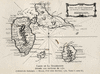 Extrait de : Trois siècles d'histoire antillaise : Martinique et Guadeloupe de 1635 à nos jours (En regard de la page 177) Résumé : Carte Siècle(s) traité(s) : 17 Droits : Domaine public Permalien : http://www.manioc.org/images/PAP110490189i1 PAP110490189i1 | Partager |
| | Carte du Canal de Bahama Auteur(s) : Bellin, Jacques Nicolas, 1703-1772 Bellin, Jacques Nicolas, 1703-1772 Éditeur(s) : Didot ( Paris ) Résumé : (Citation/Reference) Phillips, From: Description des débouquements qui sont au nord de l'isle de Saint Domingue..."Pl.XXXI." "Suivant les Remarques de plusieurs Navigateurs eten particulier des Anglais." Shows Archipelagic treatment of Florida which flourished during the early and mid 18th Century. Relief shown pictorially, dephs by soundings. Includes northwestern coast of Cuba. North oriented towards the right. Includes watermark with bunch of fruits. (Funding) Funded in part by the University of Florida, the Florida Heritage Project of the State University Libraries of Florida, the Institute for Museum and Library Services, and the U.S. Department of Education's TICFIA granting program. Bahamas Florida, Straits of Florida Bahamas Florida, Straits of Florida Bahamas Florida, Straits Florida Bahamas Florida, Straits of Florida Bahamas Florida, Straits of Florida Bahamas Florida, Straits Florida Droits : This item is presumed to be in the public domain. The University of Florida George A. Smathers Libraries respect the intellectual property rights of others and do not claim any copyright interest in this item. Users of this work have responsibility for determining copyright status prior to reusing, publishing or reproducing this item for purposes other than what is allowed by fair use or other copyright exemptions. Any reuse of this item in excess of fair use or other copyright exemptions may require permission of the copyright holder. The Smathers Libraries would like to learn more about this item and invite individuals or organizations to contact Digital Services (UFDC@uflib.ufl.edu) with any additional information they can provide. 002880450 APB1701 77840700 http://ufdc.ufl.edu/UF00004036/00001 | Partager Voir aussi Maps -- Early works to 1800 ( lcsh ) Maps -- Early works to 1800 ( lcsh ) Maps -- Early works to 1800 ( lcsh ) Early maps -- No scale -- 1768 ( local ) Early maps -- No scale -- 1768 ( local ) Early maps -- No scale -- 1768 ( local ) Early works to 1800 -- No scale -- 1768 ( local ) Early works to 1800 -- No scale -- 1768 ( local ) Early works to 1800 -- No scale -- 1768 ( local ) No scale -- 1768 ( local ) |
| | CARTE DES Provinces De Tabasco, Chiapa,Verapaz, Guatimala, Honduras et Yucatan Auteur(s) : Bellin, Jacques Nicolas, 1703-1772 Éditeur(s) : Chez Didot ( Paris ) Résumé : (Funding) Funded in part by the University of Florida, the Florida Heritage Project of the State University Libraries of Florida, the Institute for Museum and Library Services, and the U.S. Department of Education's TICFIA granting program. Honduras Guatemala Belize Mexico -- Tabasco Mexico -- Chiapas Mexico -- Yucatan Mexico -- Quinta Roo Mexico -- Oaxaca Mexico Guatemala Honduras Central America Guatemala Central America Mexico Honduras Guatemala Central America Mexico Droits : This item is presumed to be in the public domain. The University of Florida George A. Smathers Libraries respect the intellectual property rights of others and do not claim any copyright interest in this item. Users of this work have responsibility for determining copyright status prior to reusing, publishing or reproducing this item for purposes other than what is allowed by fair use or other copyright exemptions. Any reuse of this item in excess of fair use or other copyright exemptions may require permission of the copyright holder. The Smathers Libraries would like to learn more about this item and invite individuals or organizations to contact Digital Services (UFDC@uflib.ufl.edu) with any additional information they can provide. 002691411 ANF8744 http://ufdc.ufl.edu/UF90000123/00001 | Partager Voir aussi Maps -- Early works to 1800 ( lcsh ) Maps -- Early works to 1800 ( lcsh ) Maps -- Early works to 1800 ( lcsh ) Maps -- Early works to 1800 ( lcsh ) Early maps -- 1754 ( local ) Early maps -- 1754 ( local ) Early maps -- 1754 ( local ) Early Maps -- 1754 ( local ) Early Maps -- 1754 ( local ) Early Maps -- 1754 ( local ) |
| | Grundriss des Hafens von Acapulco ; Plan du port d'Acapulco sur la cote du Mexique dans la Mer du Sud Auteur(s) : Bellin, Jacques Nicolas, 1703-1772 Prévost, 1697-1763 Éditeur(s) : [s.n.] ( [Leipzig] ) Résumé : From German edition of Histoire Generale des Voyages..., by Prevost d'Exiles. Attributed to Bellin. Relief shown pictorially. Includes graphic scale in English miles. "16°45' Norderbreite und 108°22' Westlicher Loenge von London." "No 16." (Funding) Funded in part by the University of Florida, the Florida Heritage Project of the State University Libraries of Florida, the Institute for Museum and Library Services, and the U.S. Department of Education's TICFIA granting program. Acapulco (Mexico) Acapulco (Mexico) Acapulco (Mexico) Mexico, Cities Acapulco Acapulco (Mexico) Acapulco (Mexico) Acapulco (Mexico) Droits : This item is presumed to be in the public domain. The University of Florida George A. Smathers Libraries respect the intellectual property rights of others and do not claim any copyright interest in this item. Users of this work have responsibility for determining copyright status prior to reusing, publishing or reproducing this item for purposes other than what is allowed by fair use or other copyright exemptions. Any reuse of this item in excess of fair use or other copyright exemptions may require permission of the copyright holder. The Smathers Libraries would like to learn more about this item and invite individuals or organizations to contact Digital Services (UFDC@uflib.ufl.edu) with any additional information they can provide. 002356783 ALW1211 122378930 http://ufdc.ufl.edu/UF00066670/00001 | Partager |
| | Plan des Havres de Port Antonio et de Saint Francois Auteur(s) : Bellin, Jacques Nicolas, 1703-1772 Bellin, Jacques Nicolas, 1703-1772 Éditeur(s) : Bellin, Jacques Nicolas ( Paris ) Résumé : From: Le Petit Atlas Maritime Recueil De cartes Et Plans Des Quatre Parties Du Monde. "Tome I No 60" Relief represented pictorially and depth by soundings. Map oriented with East to top of map. Philips No. 3508 (Funding) Funded in part by the University of Florida, the Florida Heritage Project of the State University Libraries of Florida, the Institute for Museum and Library Services, and the U.S. Department of Education's TICFIA granting program. Jamaica Port Antonio (Jamaica) Jamaica Port Antonio (Jamaica) Jamaica Port Antonio (Jamaica) Jamaica Port Antonio (Jamaica) Jamaica Port Antonio (Jamaica) Jamaica Port Antonio (Jamaica) Droits : This item is presumed to be in the public domain. The University of Florida George A. Smathers Libraries respect the intellectual property rights of others and do not claim any copyright interest in this item. Users of this work have responsibility for determining copyright status prior to reusing, publishing or reproducing this item for purposes other than what is allowed by fair use or other copyright exemptions. Any reuse of this item in excess of fair use or other copyright exemptions may require permission of the copyright holder. The Smathers Libraries would like to learn more about this item and invite individuals or organizations to contact Digital Services (UFDC@uflib.ufl.edu) with any additional information they can provide. 002357133 ALW1570 78689039 http://ufdc.ufl.edu/UF00003794/00001 | Partager Voir aussi Maps -- Early works to 1800 ( lcsh ) Maps -- Early works to 1800 ( lcsh ) Early maps -- No scale -- 1764 ( local ) Early maps -- No scale -- 1764 ( local ) Early works to 1800 -- No scale -- 1764 ( local ) Early works to 1800 -- No scale -- 1764 ( local ) No scale -- 1764 ( local ) No scale -- 1764 ( local ) Early maps -- No scale -- 1764 ( local ) Early maps -- No scale -- 1764 ( local ) |
| | Karte von der Erdenge Panama und den Provinzen Veragua, Terra Firma und Darien Auteur(s) : Bellin, Jacques Nicolas, 1703-1772 Prévost, 1697-1763 Éditeur(s) : [s.n.] ( [Leipzig] ) Résumé : Relief shown pictorially. Prime meridian: Paris. "No. 6." From German edition of Histoire Generale des Voyages..., by Prevost d'Exiles, Antoine F. Includes scale in French miles. (Funding) Funded in part by the University of Florida, the Florida Heritage Project of the State University Libraries of Florida, the Institute for Museum and Library Services, and the U.S. Department of Education's TICFIA granting program. (Statement of Responsibility) zur allgemeinen Historie der Reisen, von dem Hrn Bellin ; Ing. de la Marine. Panama Panama Panama Panama Panama Panama Droits : This item is presumed to be in the public domain. The University of Florida George A. Smathers Libraries respect the intellectual property rights of others and do not claim any copyright interest in this item. Users of this work have responsibility for determining copyright status prior to reusing, publishing or reproducing this item for purposes other than what is allowed by fair use or other copyright exemptions. Any reuse of this item in excess of fair use or other copyright exemptions may require permission of the copyright holder. The Smathers Libraries would like to learn more about this item and invite individuals or organizations to contact Digital Services (UFDC@uflib.ufl.edu) with any additional information they can provide. 002356827 ALW1255 38306490 http://ufdc.ufl.edu/UF00066659/00001 | Partager |
| | Carte des isle situées au nord de St. Domingue Auteur(s) : Bellin, Jacques Nicolas, 1703-1772 Bellin, Jacques Nicolas, 1703-1772 Éditeur(s) : [s.n.] ( [Paris ) Résumé : From: Le Petit Atlas Maritime Recueil De cartes Et Plans Des Quatre Parties Du Monde."Tome. I, No. 62" Philips No. 3508 Relief shown pictorially. Depths shown by fathoms. Shows ship channels and anchorages. Prime meridian: Paris. Map shows frame with coordinates only in upper and left. (Funding) Funded in part by the University of Florida, the Florida Heritage Project of the State University Libraries of Florida, the Institute for Museum and Library Services, and the U.S. Department of Education's TICFIA granting program. Bahamas Bahamas Bahamas Bahamas Bahamas Bahamas Droits : This item is presumed to be in the public domain. The University of Florida George A. Smathers Libraries respect the intellectual property rights of others and do not claim any copyright interest in this item. Users of this work have responsibility for determining copyright status prior to reusing, publishing or reproducing this item for purposes other than what is allowed by fair use or other copyright exemptions. Any reuse of this item in excess of fair use or other copyright exemptions may require permission of the copyright holder. The Smathers Libraries would like to learn more about this item and invite individuals or organizations to contact Digital Services (UFDC@uflib.ufl.edu) with any additional information they can provide. 002568013 AMT4312 05412124 73697231 http://ufdc.ufl.edu/UF00071894/00001 | Partager |
| | Carte de la Rivière du maroni Auteur(s) : Bellin, Jacques-Nicolas (1703-1772) Année de publication : 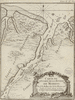 Extrait de : Description géographique de la Guyane contenant les possessions et les établissements des François, des Espagnols, des Portugais, des Hollandois dans ces vastes pays (p.161) Siècle(s) traité(s) : 18 Droits : Domaine public Permalien : http://www.manioc.org/images/FRA110910218i1 FRA110910218i1 | Partager Documents liés : Télécharger |
| | La Partie Francoise de L'isle de Saint Domingue ; The French part of the Isle of Santo Domingo Auteur(s) : Bellin, Jacques Nicolas, 1703-1772 Bellin, Jacques Nicolas, 1703-1772 Éditeur(s) : Bellin, Jacques Nicolas ( Paris ) Résumé : From: Le Petit Atlas Maritime Recueil De cartes Et Plans Des Quatre Parties Du Monde."Tome. I, No. 67" Philips No. 3508. Map shows the region of today's Haiti. Relief shown pictorially. Depths shown by fathoms. Prime meridian: Paris. Map shows frames with coordinates only in lower and left margins. Map includes compass rose close to the center. Map shows watermark with text. (Funding) Funded in part by the University of Florida, the Florida Heritage Project of the State University Libraries of Florida, the Institute for Museum and Library Services, and the U.S. Department of Education's TICFIA granting program. Haiti Droits : This item is presumed to be in the public domain. The University of Florida George A. Smathers Libraries respect the intellectual property rights of others and do not claim any copyright interest in this item. Users of this work have responsibility for determining copyright status prior to reusing, publishing or reproducing this item for purposes other than what is allowed by fair use or other copyright exemptions. Any reuse of this item in excess of fair use or other copyright exemptions may require permission of the copyright holder. The Smathers Libraries would like to learn more about this item and invite individuals or organizations to contact Digital Services (UFDC@uflib.ufl.edu) with any additional information they can provide. 002734399 ANL2212 123414576 http://ufdc.ufl.edu/UF90000251/00001 | Partager |
| | Carte des observations qui ont été faites sur la Frégate de Roi l'Emeraude en 1753 sur la Caye d'Argent Auteur(s) : Bellin, Jacques Nicolas, 1703-1772 Bellin, Jacques Nicolas, 1703-1772 Éditeur(s) : Didot ( [Paris ) Résumé : (Citation/Reference) Philips, From: Description geographique des débouquemens qui sont au nord de L'Isle de Saint Domingue.... "Pl. XXV" Map shows keys to the north of the Dominican Republic. Watermark with text on right margin. Prime meridian: Paris. (Funding) Funded in part by the University of Florida, the Florida Heritage Project of the State University Libraries of Florida, the Institute for Museum and Library Services, and the U.S. Department of Education's TICFIA granting program. Turks and Caicos Islands West Indies Bahamas Turks and Caicos Islands Turks and Caicos Islands Turks and Caicos Islands Turks and Caicos Islands Turks and Caicos Islands Droits : This item is presumed to be in the public domain. The University of Florida George A. Smathers Libraries respect the intellectual property rights of others and do not claim any copyright interest in this item. Users of this work have responsibility for determining copyright status prior to reusing, publishing or reproducing this item for purposes other than what is allowed by fair use or other copyright exemptions. Any reuse of this item in excess of fair use or other copyright exemptions may require permission of the copyright holder. The Smathers Libraries would like to learn more about this item and invite individuals or organizations to contact Digital Services (UFDC@uflib.ufl.edu) with any additional information they can provide. 002567940 AMT4239 162533761 http://ufdc.ufl.edu/UF00071891/00001 | Partager Voir aussi Maps -- Early works to 1800 ( lcsh ) Maps -- Early works to 1800 ( lcsh ) Maps -- Early works to 1800 ( lcsh ) Early works to 1800 -- 1:400,000 -- 1753 ( local ) Early maps -- 1:400,000 -- 1753 ( local ) 1:400,000 -- 1753 ( local ) Early works to 1800 -- 1:400,000 -- 1753 ( local ) Early maps -- 1:400,000 -- 1753 ( local ) |
| | Plan de l'isle à Vache à la coste de sud de S. Domingue Auteur(s) : Bellin, Jacques Nicolas, 1703-1772 Bellin, Jacques Nicolas, 1703-1772 Éditeur(s) : Bellin, Jacques Nicolas ( Paris ) Résumé : Oriented with north toward the upper left. Map shows light watermark with text. Relief shown by hachures. Depths shown by soundings. Title refers to Vache Island on the south coast of Dominican Republic, part of today's Haitian territory. "Tome I, no. 73." From: Le Petit Atlas Maritime Recueil De cartes Et Plans Des Quatre Parties Du Monde. "Tome I. No. 73" Philips No. 3508 (Funding) Funded in part by the University of Florida, the Florida Heritage Project of the State University Libraries of Florida, the Institute for Museum and Library Services, and the U.S. Department of Education's TICFIA granting program. Vache Island (Haiti) Vache Island (Haiti) Vache Island (Haiti) Vache Island (Haiti) Vache Island (Haiti) Vache Island (Haiti) Droits : This item is presumed to be in the public domain. The University of Florida George A. Smathers Libraries respect the intellectual property rights of others and do not claim any copyright interest in this item. Users of this work have responsibility for determining copyright status prior to reusing, publishing or reproducing this item for purposes other than what is allowed by fair use or other copyright exemptions. Any reuse of this item in excess of fair use or other copyright exemptions may require permission of the copyright holder. The Smathers Libraries would like to learn more about this item and invite individuals or organizations to contact Digital Services (UFDC@uflib.ufl.edu) with any additional information they can provide. 002558559 AMS4818 05409753 http://ufdc.ufl.edu/UF00066652/00001 | Partager |
| | Plan de L'Ance Au Canot Dans la Cayque du Nord Auteur(s) : Bellin, Jacques Nicolas, 1703-1772 Bellin, Jacques Nicolas, 1703-1772 Éditeur(s) : Didot ( Paris ) Résumé : From: Description des débouquements qui sont au nord de l'isle de Saint Domingue. "Pl. XVIII." Philips No. 3949; Map # 18. Relief shown pictorially, dephs by pathoms. (Funding) Funded in part by the University of Florida, the Florida Heritage Project of the State University Libraries of Florida, the Institute for Museum and Library Services, and the U.S. Department of Education's TICFIA granting program. Turks and Caicos Islands Bahamas Turks and Caicos Islands Bahamas Turks and Caicos Islands Bahamas Turks and Caicos Islands Bahamas Turks and Caicos Islands Bahamas Turks and Caicos Islands Bahamas Droits : This item is presumed to be in the public domain. The University of Florida George A. Smathers Libraries respect the intellectual property rights of others and do not claim any copyright interest in this item. Users of this work have responsibility for determining copyright status prior to reusing, publishing or reproducing this item for purposes other than what is allowed by fair use or other copyright exemptions. Any reuse of this item in excess of fair use or other copyright exemptions may require permission of the copyright holder. The Smathers Libraries would like to learn more about this item and invite individuals or organizations to contact Digital Services (UFDC@uflib.ufl.edu) with any additional information they can provide. 002830013 ANW0385 81109417 http://ufdc.ufl.edu/UF90000434/00001 | Partager Voir aussi Maps -- Early works to 1800 ( lcsh ) Maps -- Early works to 1800 ( lcsh ) Early maps -- No scale -- 1768 ( local ) Early maps -- No scale -- 1768 ( local ) Early works to 1800 -- No scale -- 1768 ( local ) Early works to 1800 -- No scale -- 1768 ( local ) No scale -- 1768 ( local ) No scale -- 1768 ( local ) Early maps -- No scale -- 1768 ( local ) Early maps -- No scale -- 1768 ( local ) |
| | Carte de l'ïle de Caïenne et de ses environs Auteur(s) : Bellin, Jacques-Nicolas (1703-1772) 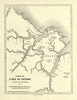 Extrait de : La Guyane française : notes et souvenirs d'un voyage exécuté en 1862-1863 (p.110) Résumé : Carte de l'Ile de Cayenne Siècle(s) traité(s) : 19 Droits : Domaine public Provenance : Université des Antilles et de la Guyane. Service commun de la documentation Permalien : http://www.manioc.org/images/HASH01cac790f3bcbdc081a5ec2d HASH01cac790f3bcbdc081a5ec2d | Partager Voir aussi
Télécharger |
| | Carte de l'Ifle de Cayenne Auteur(s) : Bellin, Jacques-Nicolas (1703-1772) Année de publication : 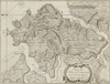 Extrait de : Description géographique de la Guyane contenant les possessions et les établissements des François, des Espagnols, des Portugais, des Hollandois dans ces vastes pays (p.180) Siècle(s) traité(s) : 18 Droits : Domaine public Permalien : http://www.manioc.org/images/FRA110910248i1 FRA110910248i1 | Partager Documents liés : Télécharger |
| | Carte réduite pour la navigation de Cayenne à la Martinique Auteur(s) : Bellin, Jacques-Nicolas (1703-1772) 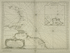 Extrait de : Frontières entre le Brésil et la Guyane française. Second mémoire présenté par les Etats-Unis du Brésil au Gouvernement de la Confédération Suisse, arbitre choisi selon les stipulations du traité conclu à Rio-de-Janeiro, le 10 avril 1897 entre le Brésil et la France. Tome VI. Atlas (N°37) Résumé : Carte représentant le nord est de l'Amérique du sud et une partie des Antilles Siècle(s) traité(s) : 18 Droits : Domaine public Permalien : http://www.manioc.org/images/B_CG973FRAN_RES_00F-15010_006_0037 B_CG973FRAN_RES_00F-15010_006_0037 | Partager Voir aussi Télécharger |
| | Carte de la Guyane Françoife Auteur(s) : Bellin, Jacques-Nicolas (1703-1772) Année de publication : 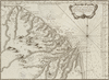 Extrait de : Description géographique de la Guyane contenant les possessions et les établissements des François, des Espagnols, des Portugais, des Hollandois dans ces vastes pays (p.158) Siècle(s) traité(s) : 18 Droits : Domaine public Permalien : http://www.manioc.org/images/FRA110910214i1 FRA110910214i1 | Partager Documents liés : Télécharger |