Isle de la Martinique (on sheet with) Isles de la Guadeloupe, de Marie Galante, De la Desirade, et Calles des Saintes Auteur(s) : Bonne, Rigobert, 1727-1794 Éditeur(s) : [s.n.] ( Paris ) Résumé : From: "Atlas Encyclopedique... et Les Cartes Relatives a La Geographie Physique, p 110. (Funding) Funded in part by the University of Florida, the Florida Heritage Project of the State University Libraries of Florida, the Institute for Museum and Library Services, and the U.S. Department of Education's TICFIA granting program. Martinique Guadeloupe -- Marie Galante Guadeloupe -- La Desirade Guadeloupe -- Les Saintes Droits : This item is presumed to be in the public domain. The University of Florida George A. Smathers Libraries respect the intellectual property rights of others and do not claim any copyright interest in this item. Users of this work have responsibility for determining copyright status prior to reusing, publishing or reproducing this item for purposes other than what is allowed by fair use or other copyright exemptions. Any reuse of this item in excess of fair use or other copyright exemptions may require permission of the copyright holder. The Smathers Libraries would like to learn more about this item and invite individuals or organizations to contact Digital Services (UFDC@uflib.ufl.edu) with any additional information they can provide. 003374539 http://ufdc.ufl.edu/UF00029174/00001 | Partager Voir aussi |
Partie méridionale, de l'ancien Méxique ou de la Nouvelle Espagne. L'itinéraire de Ravenau de Lussan à travers le Nicaragua et le Honduras. Auteur(s) : Bonne, Rigobert (1727-1794) Éditeur(s) : Paris : éditions Duchartre et Van Buggenhoudt Extrait de : Les frères de La Coste, Flibustiers et Corsaires (p. 70) Résumé : Carte de la l'Amérique centrale. Permalien : http://www.manioc.org/images/FCL18014-0092i1 FCL18014-0092i1 | Partager |
Supplement Pour Les Isles Antilles, Extrait Des Carte Angloises Auteur(s) : Bonne, Rigobert, 1727-1794 Éditeur(s) : 
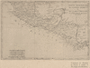
[s.n.] ( Paris ) Résumé : Contains 10 inset maps which illustrate the Antilles from the Virgin Islands to Tabago. "LW.X.XII.XIII et XIV" "No 49" (Funding) Funded in part by the University of Florida, the Florida Heritage Project of the State University Libraries of Florida, the Institute for Museum and Library Services, and the U.S. Department of Education's TICFIA granting program. Antigua and Barbuda -- Antigua Antigua and Barbuda -- Barbuda Saint Kitts and Nevis -- Saint Kitts Netherlands Antilles -- Saint Martin Dominica Saint Lucia Barbados Anguilla Grenada Puerto Rico Trinidad and Tobago -- Tobago Saint Vincent and the Grenadines -- Saint Vincent United States Virgin Islands British Virgin Islands Antilles, Lesser Windward Islands (West Indies) Antilles, Lesser Windward Islands Antilles, Lesser Windward Islands Droits : This item is presumed to be in the public domain. The University of Florida George A. Smathers Libraries respect the intellectual property rights of others and do not claim any copyright interest in this item. Users of this work have responsibility for determining copyright status prior to reusing, publishing or reproducing this item for purposes other than what is allowed by fair use or other copyright exemptions. Any reuse of this item in excess of fair use or other copyright exemptions may require permission of the copyright holder. The Smathers Libraries would like to learn more about this item and invite individuals or organizations to contact Digital Services (UFDC@uflib.ufl.edu) with any additional information they can provide. 002829551 ANV9921 http://ufdc.ufl.edu/UF90000441/00001 | Partager |
Carte de L'Isle de St. Domingue une des Grandes Antilles, Colonies Francoise et Espagnole ; Atlas de Toutes les Parties Connues Du Globe Terrestre, Dresse Auteur(s) : Bonne, Rigobert, 1727-1794 Éditeur(s) : [s.n.] ( Paris ) Résumé : "Lw,X,XII,et XIII" "No 37". Similar titles from 1770 to 1783 but is reported to be from the 1780 edition of the Atlas de Toutes... Bahamas Turks and Caicos Cuba Haiti Dominican Republic Haiti Dominican Republic Hispaniola Dominican Republic Haiti Hispaniola Hispaniola Haiti Dominican Republic Droits : This item is presumed to be in the public domain. The University of Florida George A. Smathers Libraries respect the intellectual property rights of others and do not claim any copyright interest in this item. Users of this work have responsibility for determining copyright status prior to reusing, publishing or reproducing this item for purposes other than what is allowed by fair use or other copyright exemptions. Any reuse of this item in excess of fair use or other copyright exemptions may require permission of the copyright holder. The Smathers Libraries would like to learn more about this item and invite individuals or organizations to contact Digital Services (UFDC@uflib.ufl.edu) with any additional information they can provide. AAA5872 ALW1612 002357175 2229 http://ufdc.ufl.edu/UF00004618/00001 | Partager |
Partie Meridionale, De L'ancien Mexique ou De La Nouvle Espagne Auteur(s) : Bonne, Rigobert, 1727-1794 Éditeur(s) : [s.n.] ( Paris ) Résumé : From: Atlas Geographique...a L'Histoire. "Liv.VI.X" "No.27" Andre Sculp. (Funding) Funded in part by the University of Florida, the Florida Heritage Project of the State University Libraries of Florida, the Institute for Museum and Library Services, and the U.S. Department of Education's TICFIA granting program. Mexico Guatemala Belize El Salvador Nicaragua Costa Rica Panama Mexico Central America Mexico Central America Mexico Central America Droits : This item is presumed to be in the public domain. The University of Florida George A. Smathers Libraries respect the intellectual property rights of others and do not claim any copyright interest in this item. Users of this work have responsibility for determining copyright status prior to reusing, publishing or reproducing this item for purposes other than what is allowed by fair use or other copyright exemptions. Any reuse of this item in excess of fair use or other copyright exemptions may require permission of the copyright holder. The Smathers Libraries would like to learn more about this item and invite individuals or organizations to contact Digital Services (UFDC@uflib.ufl.edu) with any additional information they can provide. 002730190 ANK7956 http://ufdc.ufl.edu/UF00073875/00001 | Partager |
Les Isles Antilles, et le Golfe du Mexique Auteur(s) : Bonne, Rigobert, 1727-1794 Résumé : Map including the coasts of the southern United States, Central America, northern South America, and the West Indies. The map is very detailed, depicting rivers and mountain elevations in all of these areas. Mexico, Gulf of Droits : Use of this item is provided for non-commercial, personal, educational, and research use only. For information about the copyright and reproduction rights for this item, please contact Special Collections, Florida State University Libraries, Tallahassee, Florida. fsu:6691 FSDT2975597 oai:fsu.digital.flvc.org:fsu_6691 http://ufdc.ufl.edu/FSUM000009/00001 | Partager |
LES PETITES ANTILLES ou LES ISLES DU VENT, avec CELLES DE SOUS LE VENT Auteur(s) : Bonne, Rigobert, 1727-1794 Éditeur(s) : [s.n.] ( Paris ) Résumé : "109" Andre Sculp. (Funding) Funded in part by the University of Florida, the Florida Heritage Project of the State University Libraries of Florida, the Institute for Museum and Library Services, and the U.S. Department of Education's TICFIA granting program. Anguilla Antigua and Barbuda Aruba Barbados Bermuda British Virgin Islands Cayman Islands Colombia Dominica Dominican Republic Grenada Guadeloupe Martinique Montserrat Netherlands Antilles Puerto Rico Saint Kitts and Nevis Saint Lucia Saint Vincent and the Grenadines Trinidad and Tobago United States Virgin Islands Venezuela Antilles, Lesser West Indies Antilles, Lesser West Indies Antilles, Lesser West Indies Droits : This item is presumed to be in the public domain. The University of Florida George A. Smathers Libraries respect the intellectual property rights of others and do not claim any copyright interest in this item. Users of this work have responsibility for determining copyright status prior to reusing, publishing or reproducing this item for purposes other than what is allowed by fair use or other copyright exemptions. Any reuse of this item in excess of fair use or other copyright exemptions may require permission of the copyright holder. The Smathers Libraries would like to learn more about this item and invite individuals or organizations to contact Digital Services (UFDC@uflib.ufl.edu) with any additional information they can provide. 002734410 ANL2223 http://ufdc.ufl.edu/UF90000250/00001 | Partager |
Carte Des Isles de St. Domingue Et De Porto-Rico ; Atlas Portatif A l"Usage Des Colleges... by L'Abbe Grenet Auteur(s) : Bonne, Rigobert, 1727-1794 Éditeur(s) : L'Abbe Grenet ( Paris ) Résumé : (Internal Comments) auto insert Puerto Rico extends beyond the border. Includes the Caicos and Turk Islands. Turks and Caicos Dominican Republic Puerto Rico Haiti Dominican Republic Haiti Hispaniola Puerto Rico Haiti Dominican Republic Puerto Rico Hispaniola Haiti Dominican Republic Puerto Rico Hispaniola Droits : This item is presumed to be in the public domain. The University of Florida George A. Smathers Libraries respect the intellectual property rights of others and do not claim any copyright interest in this item. Users of this work have responsibility for determining copyright status prior to reusing, publishing or reproducing this item for purposes other than what is allowed by fair use or other copyright exemptions. Any reuse of this item in excess of fair use or other copyright exemptions may require permission of the copyright holder. The Smathers Libraries would like to learn more about this item and invite individuals or organizations to contact Digital Services (UFDC@uflib.ufl.edu) with any additional information they can provide. AAB0511 APT9757 003047576 http://ufdc.ufl.edu/UF00018305/00001 | Partager Voir aussi Maps -- Early works to 1800 ( lcsh ) Maps -- Early works to 1800 ( lcsh ) Early Works to 1800 -- Maps ( lcsh ) Early Works to 1800 -- Maps ( lcsh ) Early maps -- 1782 ( local ) Early maps -- 1782 ( local ) Early maps -- 1782 ( local ) Early maps -- 1782 ( local ) Early Maps -- 1782 ( local ) Early maps -- 1782 ( local ) |